
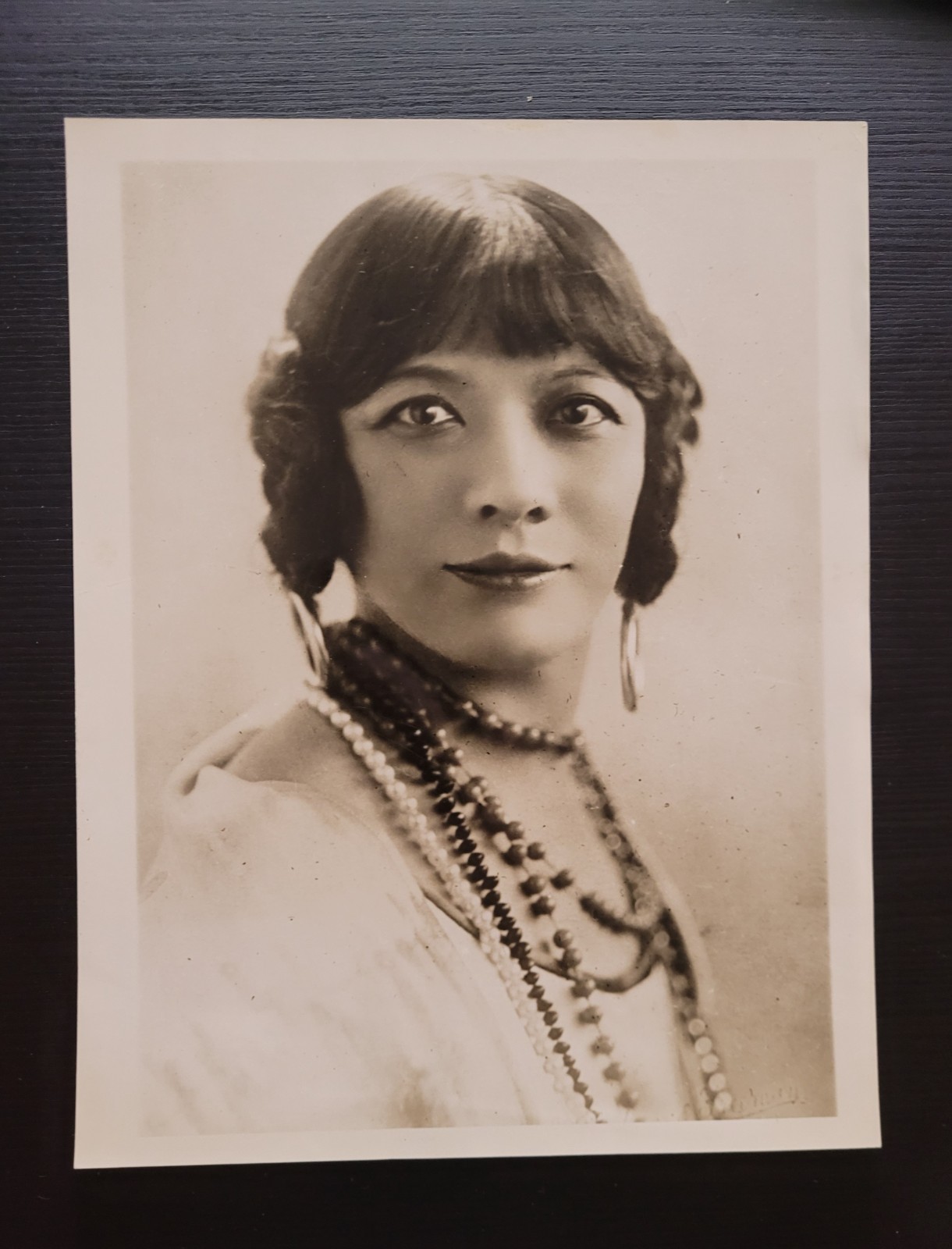
Antique photograph original period image China Rose Quong 1931 photo Chinese For Sale
When you click on links to various merchants on this site and make a purchase, this can result in this site earning a commission. Affiliate programs and affiliations include, but are not limited to, the eBay Partner Network.

Antique photograph original period image China Rose Quong 1931 photo Chinese:
$500.00
An extremely scarce photo of Rose Quong from 1931 measuring approximately 6.5x8.5 inchesRose Maud Quong (15 August 1879 – 14 December 1972) was a Chinese Australian actress, performer and writer.Photo QUONG
BAJA
A CHINESE GIRL WHOSE STAR ON THE LITERARY
HORIZON IS STARTLING
Photo by
UNDERWOOD
and
LONDON, Eng.--Miss Rose Quong, a native Chinese
girl whose literary ability has startled the book
world of this city where she makes her home. Her
books are among the best sellers and in looks she
is not hard on the eyes. She is a distinct type
of Chinese beauty.
730R305
ROSE QUONG
______________________ROSE QUONG1924-19732.75 ft.MSS 127byMonique BourqueSeptember 1993BIOGRAPHICAL NOTERose Quong was born ca. 1879 in Melbourne, Australia, the daughter of Chinese parents Chun Quong and Annie Moy Quong. She grew up in Australia and was employed by the government and performed with the Melbourne Repertory Players until 1924, when she went to study acting in England. She opened in several plays in 1924, receiving excellent reviews from critics. She worked in England and France before coming to the United States for the first time in 1936 on tour. She returned to the United States on a lecture tour in 1940 and remained permanently, settling in New York City. She continued her acting career in America, and also delivered lectures on Chinese drama, art, and culture. She performed primarily in theater, but had several film roles to her credit, including a small part in "Flower Drum Song".The backbone of Quong's career in the United States was a series of one-woman shows, consisting of recitations, dramatic readings, and scenes from plays. She authored two books: Chinese Characters, Their Wit and Wisdom, and a translation of Sung-Ling P'u, Chinese Ghost and Love Stories. Her last role was in a 1971 film, "Eliza's Horoscope". To supplement her income as an actress, Quong occasionally took on other jobs, working as a secretary.Quong was deeply interested in Chinese philosophy, and studied it for much of her life; her presentations frequently included material from the I China. She also studied yoga, astrology, and Chinese history. A voracious reader, she maintained reading lists and took copious notes on her reading.She died in New York City in 1972.PROVENANCEThe collection was donated to the Balch Institute by Alexandra Hunt in 1982.SCOPE AND CONTENT NOTERose Quong's papers are of value to researchers examining the history of the theatre in the early twentieth century. Because she was an actress, the collection presents a carefully-constructed public self; this image is of interest to anyone looking at how Asians have presented themselves to mainstream American culture, and at how they have been portrayed in various forms of entertainment and the press.The bulk of the correspondence in Series One is concerned with the publication of Quong's two books, and the receipt of royalties for their sales. Of special interest is the correspondence related to her attempts to become a citizen, which was complicated by immigration quota restrictions and by her profession. Some letters are concerned with her public appearances, but most of these were placed in the scrapbooks in Series Three.Series Two, Writings, is the most difficult to use, as it is the least organized (see Processing Notes). The series includes notes and musings on readings in Chinese philosophy and history; notes on health, diet, and exercise, including yoga; partial translations of Chinese texts and individual words and related notes, and notes and musings on astrology, the occult, and human relationships. Also present are language exercises in German and French. The diaries and journal detail her daily activities in London, France, and America, but provide little information Quong's relationships with other people; these are of value in illuminating her training in London in particular (and the theatre community there), and her attempts to make a name for herself in the theatre.Of greatest interest in Series Three are two scrapbooks of materials related to Quong's acting career. Included are newspaper reviews, correspondence, portrait and other photographs, a pencil portrait of Quong, programs, and what appears to be a nearly complete script for one of Quong's theatrical successes, a London production of "Lady Precious Stream" which starred Chinese American actress Anna May Wong. The reviews in particular provide an overview of Quong's most active period in the profession, the 1920s through the 1940s.Series Four, Sound Recordings, appears to be of value in illuminating Quong's interest in astrology and the occult, and in documenting her performing style. These tapes, which are currently on reels, must be transferred to audiocassettes before they can be made available for research use.PROCESSING NOTEBecause Quong frequently used both sides of sheets and combined notes and other writings both topically and chronologically (and dates are often missing) in single volumes or notebooks, no attempt has been made to organize the loose materials in Series Two by subject; rather, the original order of these writings has been maintained. Photographs have been separated to Photo Group 352.SERIES DESCRIPTIONSThe papers of Rose Quong have been divided into three series: I. Correspondence; II. Writings; III. Printed Materials and Ephemera; IV. Sound Recordings.SERIES I. CORRESPONDENCE, 1942-1973 and n.d. (6 folders). This series contains personal and business correspondence and related materials. Correspondence from 1973 is with Quong's executor and concerns both personal and business matters.SERIES II. WRITINGS, 1924-1957 and n.d. (1.5 ft.). This series consists primarily of Quong's diaries and journals and related materials. Also present is a manuscript co-authored by Quong, a re-telling of a Chinese folktale.SERIES III. PRINTED MATERIALS AND EPHEMERA, 1923-1958 (.5 ft.). This series is primarily composed of two scrapbooks of clippings and related materials pertaining to Quong's career. Also present are the proceedings of a conference sponsored by the League for Industrial Democracy, presumably attended by Quong, and sections of two scripts.SERIES IV. SOUND RECORDINGS, n.d. (.5 ft.). This series consists of ten audiotapes. Most are Rose Quong reading Chinese poetry; she does, however, read some T.S. Eliot ("The Waste Land"). One of the tapes is Quong telling a story, another contains two lectures, and two of the tapes of "metaphysical readings" for Miss Quong, followed by her discussions with the reader.The box list of the Register of the Papers of Rose Quong is four pages long.Rose Quong was one of Australia’s first great actors. During a career that spanned decades, continents, from stage to screen, Rose not only performed alongside some of the most famous men and women of the twentieth century but held her own while doing so. As a Chinese-Australian living during the years of the White Australia Policy, her achievements both on and off the stage are even more astounding.Portrait of Rose Quong presumably taken in Australia.Portrait of Rose Quong, presumably in Australia [Image courtesy Papers of Rose Quong, National Library of Australia, NLA MS 9796]
Little is known of Rose’s early life in Melbourne. She was the eldest child of Chun and Annie Moy Quong, sister to Norman who would go on to become a court reporter for the Supreme Court of New South Wales. Though she clearly excelled in school, passing the matriculation exam at the University of Melbourne in nine subjects, she never formally enrolled at a tertiary institution. In her own words, “the theatre got hold of me,” though historian Angela Woollacott suggests she may have been expected to provide an income for her brothers’ education rather than continue study herself. [1]By the time she was eighteen Rose had a job as a public servant, but her love of performing never wavered. She learned to read Shakespeare and poetry in the 1890s and won an elocution prize for her efforts in 1903. She also helped found the Mermaid Play Society alongside students from the university. Her performances in amateur shows and competitions over the next two decades earned her a number of glowing mentions in local media. By 1923, one commentator noted that “Miss Quong has been connected with pretty well every dramatic movement in Melbourne.” [2]Rose’s life changed in 1924 when she was forty-four years old. Winning a scholarship to study drama in London at the academy of Rosina Filippi, Rose left her home and family for an acting career overseas. “I was crazy on Shakespeare and Dickens,” Rose later recalled. “I wanted to go to London … I needed a new experience, change.” [3] She would never return to Australia.Life in London was not all Rose had imagined. Her passion for Shakespeare met with resistance from interwar British society who instead encouraged her towards a career in “Oriental” recitation. Rose’s race had never dictated her career in Melbourne; in fact, most audiences and critics simply ignored it. This was characteristic of White Australia at the time, who embraced the successes of Chinese-Australians so long as their Chinese descent could be overlooked. In London it was the opposite – Rose’s Chinese heritage defined her. Her role as Yu-Pi in the 1929 production of The Circle of Chalk alongside Laurence Olivier and Anna May Wong earned her great critical acclaim, but most reviews characterised both Rose and Anna May as Chinese actresses, omitting their Australian and American identities respectively. [4]Rose moved to America in the 1930s and embarked on a career as both a lecturer and writer. She continued to perform in such productions as Roger and Hammerstein’s The Flower Drum Song, and in 1971, the year before her death, she played herself in Canadian film Eliza’s Horoscope alongside Tommy Lee Jones. [5] Rose would never have reached the heights of fame she did without leaving Melbourne. Though cultural stereotyping dictated much of her career in Britain and the United States, Rose came to embrace her Chinese heritage, making her first and only visit to the country in 1936. Privately, however, and despite spending more than half of her life abroad, she still considered herself Australian. Shortly before her death in New York in 1972, she recalled a childhood spent “crushing in my hands eucalyptus leaves.” [6] Today, Rose deserves to be remembered for her Chinese and Australian identities – as a woman who embraced her passions, and never gave up on her dreams.Rose Quong was born to Chinese merchants in Melbourne in 1879.Her youth coincided with the heyday of anti-Chinese racism and the White Australia Policy but by her death in 1972 she had become one of Australia's most successful exports.Because she was ethnically Chinese, she wasn't acclaimed as an Australian star.La Trobe University Yves Rees shares the story of this remarkable and determined woman.The story of Rose Quong (1879–1972) reveals how an Australian learned to use the pervasive Orientalism of the early twentieth century to her own ends. Quong claimed an essential ability to interpret Chinese culture, forging a career out of lecturing and writing on Chinese literature and traditions, and performing her own Chineseness. She juggled her mixed Australian, British and Chinese heritage in both London and New York, showing the plasticity and transportability of ethnic identities. Quong's story points to the role of London as imperial metropolis in the staging of an Australian's transnational career, even for an Australian whose imaginary homeland was China. The fact that Quong was embraced by the Australian community in London adds a new perspective on White Australia, even though that community was instrumental in steering her towards Chineseness and Orientalism.Rose Maud Quong (15 August 1879 – 14 December 1972) was a Chinese Australian actress, performer and writer.
Early lifeBorn in East Melbourne, Australia to merchant Chun Quong and Annie née Moy Quong, Rose Maud Quong grew up in Melbourne, where she attended University High School and passed her matriculation exams. At one time she intended to study medicine, but from 1897 to 1919 was employed as a public servant in a variety of clerical roles. Quong showed great interest in amateur theatricals, winning competitions and performing with the Melbourne Repertory Players until in 1924, at age 44, she won a scholarship to study drama in England.[citation needed]She opened in several plays in 1924, receiving excellent reviews from critics. Over the next fifteen years she learnt Mandarin, studied Chinese culture, lectured, recited Chinese poetry and acted in England and France before visiting the United States for the first time in 1934 on tour. Her biographer, Angela Woollacott, notes that the Australian expatriate community in London embraced her, despite the aims of Australia's own White Australia Policy.[1]In 1936 she made her only trip to China, where she lectured to elite audiences, in Mandarin. She returned to the United States on a lecture tour in January 1939 and remained permanently, settling in New York City.
Life in United StatesQuong continued her acting career in the United States, and also delivered lectures on Chinese drama, art, and culture. She performed primarily in theatre, but had several film roles to her credit, including a small part in Flower Drum Song. The backbone of Quong's career in the United States was a series of one-woman shows, consisting of recitations, dramatic readings, and scenes from plays. She authored two books: Chinese Wit, Wisdom, and Written Characters, and a translation of selected stories from P'u Sung-Ling's Strange Tales from a Chinese Studio under the title Chinese Ghost and Love Stories.[2] Her last role was in a 1971 film, Eliza's Horoscope. To supplement her income as an actress, Quong occasionally took on other jobs, working as a secretary.
InterestsQuong was deeply interested in Chinese philosophy, and studied it for much of her life; her presentations frequently included material from the I Ching. She also studied yoga, astrology, and Chinese history. A voracious reader, she maintained reading lists and took copious notes on her reading.
DeathRose Quong died in New York City in 1972.
ReferencesMelbourne (/ˈmɛlbərn/ MEL-bərn,[note 1] locally [ˈmæɫbən] ⓘ; Boonwurrung/Woiwurrung: Narrm or Naarm[9][10]) is the capital and most populous city of the Australian state of Victoria, and the second most-populous city in Australia, after Sydney.[1] The city's name generally refers to a 2,453 km2 (947 sq mi) area,[2] comprising an urban agglomeration of 31 local government areas.[11] The name is also used to specifically refer to the local government area named City of Melbourne, whose area is centred on the Melbourne central business district and some immediate surrounds.The city occupies much of the northern and eastern coastlines of Port Phillip Bay. As of 2024, the population of the city was 5.35 million, or 19% of the population of Australia;[1] inhabitants are referred to as "Melburnians".The area of Melbourne has been home to Aboriginal Victorians for over 40,000 years and serves as an important meeting place for local Kulin nation clans.[12][13] Of the five peoples of the Kulin nation, the traditional custodians of the land encompassing Melbourne are the Boonwurrung, Woiwurrung and the Wurundjeri peoples. In 1803, a short-lived British penal settlement was established at Port Phillip, then part of the Colony of New South Wales. Melbourne was founded in 1835 with the arrival of free settlers from Van Diemen's Land (modern-day Tasmania).[12] It was incorporated as a Crown settlement in 1837, and named after the then-Prime Minister of the United Kingdom, William Lamb, 2nd Viscount Melbourne.[12] Declared a city by Queen Victoria in 1847, it became the capital of the newly separated Colony of Victoria in 1851.[14] During the 1850s Victorian gold rush, the city entered a lengthy boom period that, by the late 1880s, had transformed it into Australia's, and one of the world's, largest and wealthiest metropolises.[15][16] After the federation of Australia in 1901, Melbourne served as the interim seat of government of the new nation until Canberra became the permanent capital in 1927.[17]Today, Melbourne is culturally diverse and, among world cities, has the fourth-largest foreign born population. It is a leading financial centre in the Asia-Pacific region, ranking 28th globally in the 2024 Global Financial Centres Index.[18] The city's eclectic architecture blends Victorian era structures, such as the World Heritage-listed Royal Exhibition Building, with one of the world's tallest skylines. Additional landmarks include the Melbourne Cricket Ground and the National Gallery of Victoria. Noted for its cultural heritage, the city gave rise to Australian rules football, Australian impressionism and Australian cinema, and is noted for its street art, live music and theatre scenes. It hosts major annual sporting events, such as the Australian Grand Prix and the Australian Open, and also hosted the 1956 Summer Olympics. Melbourne ranked as the world's most livable city for much of the 2010s.[19]Melbourne Airport is the second-busiest airport in Australia and the Port of Melbourne is the nation's busiest seaport.[20][21] Its main metropolitan rail terminus is Flinders Street station and its main regional rail and road coach terminus is Southern Cross station. It also has Australia's most extensive freeway network and the largest urban tram network in the world.[22]
History
Further information: History of Melbourne
For a chronological guide, see Timeline of Melbourne history.
Indigenous people
Further information: Aboriginal Victorians and Aboriginal AustraliansAboriginal Australians have lived in the Melbourne area for at least 40,000 years.[23] When British colonists arrived in the 19th century, at least 20,000 Kulin people from three distinct language groups – the Wurundjeri, Bunurong and Wathaurong – resided in the area.[24][25] It was an important meeting place for the clans of the Kulin nation alliance and a vital source of food and water.[26][13] In June 2021, the boundaries between the land of two of the traditional owner groups, the Wurundjeri and Bunurong, were agreed after being drawn up by the Victorian Aboriginal Heritage Council. The borderline runs across the city from west to east, with the CBD, Richmond and Hawthorn included in Wurundjeri land, and Albert Park, St Kilda and Caulfield on Bunurong land.[27] However, this change in boundaries is still disputed by people on both sides of the dispute including N'arweet Carolyn Briggs.[28] The name Narrm is commonly used by the broader Aboriginal community to refer to the city, stemming from the traditional name recorded for the area on which the Melbourne city centre is built.[29][9] The word is closely related to Narm-narm, being the Boonwurrung word for Port Phillip Bay.[30] Narrm means scrub in Eastern Kulin languages which reflects the Creation Story of how the Bay was filled by the creation of the Birrarung (Yarra River). Before this, the dry Melbourne region extended out into the Bay and the Bay was filled with teatree scrub where boorrimul (emu) and marram (kangaroo) were hunted.[31][32]
British colonisation
Further information: Foundation of MelbourneThe first British settlement in Victoria, then part of the penal colony of New South Wales, was established by Colonel David Collins in October 1803, at Sullivan Bay, near present-day Sorrento. The following year, due to a perceived lack of resources, these settlers relocated to Van Diemen's Land (present-day Tasmania) and founded the city of Hobart. It would be 30 years before another settlement was attempted.[33]
A late 19th-century artist's depiction of John Batman's treaty with a group of Wurundjeri elders.In May and June 1835, John Batman, a leading member of the Port Phillip Association in Van Diemen's Land, explored the Melbourne area, and later claimed to have negotiated a purchase of 2,400 km2 (600,000 acres) with eight Wurundjeri elders. However, the nature of the treaty has been heavily disputed, as none of the parties spoke the same language, and the elders likely perceived it as part of the gift exchanges which had taken place over the previous few days amounting to a tanderrum ceremony which allows temporary, not permanent, access to and use of the land.[34][35] Batman selected a site on the northern bank of the Yarra River, declaring that "this will be the place for a village" before returning to Van Diemen's Land.[36] In August 1835, another group of Vandemonian settlers arrived in the area and established a settlement at the site of the current Melbourne Immigration Museum. Batman and his group arrived the following month and the two groups ultimately agreed to share the settlement, initially known by the native name of Dootigala.[37][38]Batman's Treaty with the Aboriginal elders was annulled by Richard Bourke, the Governor of New South Wales (who at the time governed all of eastern mainland Australia), with compensation paid to members of the association.[26] In 1836, Bourke declared the city the administrative capital of the Port Phillip District of New South Wales, and commissioned the first plan for its urban layout, the Hoddle Grid, in 1837.[39] Known briefly as Batmania,[40] the settlement was named Melbourne on 10 April 1837 by Bourke[41] after the British Prime Minister, William Lamb, 2nd Viscount Melbourne, whose seat was Melbourne Hall in the market town of Melbourne, Derbyshire.[42] That year, the settlement's general post office officially opened with that name.[43]
Melbourne in 1840.Between 1836 and 1842, Victorian Aboriginal groups were largely dispossessed of their land by British colonists.[44] In 1840, the Superintendent of the Port Phillip District, Charles La Trobe issued a directive to banish Aborigines from the immediate vicinity of Melbourne.[45] This was enforced later that same year by the mass-arrest and imprisonment of hundreds of Indigenous people during the Lettsom raid.[46] However, Aboriginal people still managed to continue living near the settlement and by January 1844 there were said to be 675 residing in squalid camps around Melbourne.[47] The British Colonial Office had appointed five Aboriginal Protectors for the Aboriginal people of Victoria, in 1839, but their work was nullified by a land policy that favoured squatters who took possession of Aboriginal lands.[48] By 1845, fewer than 240 wealthy Europeans held all the pastoral licences then issued in Victoria and became a powerful political and economic force in Victoria for generations to come.[49] Letters patent of Queen Victoria, issued on 25 June 1847, declared Melbourne a city.[14] On 1 July 1851, the Port Phillip District separated from New South Wales to become the Colony of Victoria, with Melbourne as its capital.[50]
Victorian gold rush
South Melbourne's "Canvas Town" provided temporary accommodation for the thousands of migrants who arrived each week during the 1850s gold rush.
A large crowd outside the Victorian Supreme Court, celebrating the release of the Eureka rebels in 1855.
Further information: Victorian gold rushThe discovery of gold in Victoria in mid-1851 sparked a gold rush, and Melbourne, the colony's major port, experienced rapid growth. Within months, the city's population had nearly doubled from 25,000 to 40,000 inhabitants.[51] Exponential growth ensued, and by 1865 Melbourne had overtaken Sydney as Australia's most populous city.[52]An influx of intercolonial and international migrants, particularly from Europe and China, saw the establishment of slums, including Chinatown and a temporary "tent city" on the southern banks of the Yarra. In the aftermath of the 1854 Eureka Rebellion, mass public support for the plight of the miners resulted in major political changes to the colony, including improvements in working conditions across mining, agriculture, manufacturing and other local industries. At least twenty nationalities took part in the rebellion, giving some indication of immigration flows at the time.[53]With the wealth brought in from the gold rush and the subsequent need for public buildings, a program of grand civic construction soon began. The 1850s and 1860s saw the commencement of Parliament House, the Treasury Building, the Old Melbourne Gaol, Victoria Barracks, the State Library, University of Melbourne, General Post Office, Customs House, the Melbourne Town Hall, St Patrick's cathedral, though many remained incomplete for decades.[citation needed]The layout of the inner suburbs on a largely one-mile grid pattern, cut through by wide radial boulevards and parklands surrounding the central city, was largely established in the 1850s and 1860s. These areas rapidly filled with the ubiquitous terrace houses, as well as with detached houses and grand mansions, while some of the major roads developed as shopping streets. Melbourne quickly became a major finance centre, home to several banks, the Royal Mint, and (in 1861) Australia's first stock exchange.[54] In 1855, the Melbourne Cricket Club secured possession of its now famous ground, the MCG. Members of the Melbourne Football Club codified Australian football in 1859,[55] and in 1861, the first Melbourne Cup race was held. Melbourne acquired its first public monument, the Burke and Wills statue, in 1864.[56]With the gold rush largely over by 1860, Melbourne continued to grow on the back of continuing gold-mining, as the major port for exporting the agricultural products of Victoria (especially wool) and with a developing manufacturing sector protected by high tariffs. An extensive radial railway network spread into the countryside from the late 1850s. Construction started on further major public buildings in the 1860s and 1870s, such as the Supreme Court, Government House, and the Queen Victoria Market. The central city filled up with shops and offices, workshops, and warehouses. Large banks and hotels faced the main streets, with fine townhouses in the east end of Collins Street, contrasting with tiny cottages down laneways within the blocks. The Aboriginal population continued to decline, with an estimated 80% total decrease by 1863,[citation needed] due primarily to introduced diseases (particularly smallpox[24]), frontier violence and dispossession of their lands.[57]
Land boom and bust
Elizabeth Street lined with buildings from the "Marvellous Melbourne" era.The 1880s saw extraordinary growth: consumer confidence, easy access to credit, and steep increases in land prices led to an enormous amount of construction. During this "land boom", Melbourne reputedly became the richest city in the world,[15] and the second-largest (after London) in the British Empire.[58]The decade began with the Melbourne International Exhibition in 1880, held in the large purpose-built Exhibition Building. A telephone exchange was established that year, and the foundations of St Paul's were laid. In 1881, electric light was installed in the Eastern Market, and a generating station capable of supplying 2,000 incandescent lamps was in operation by 1882.[59] The Melbourne cable tramway system opened in 1885 and became one of the world's most extensive systems by 1890.[60]In 1885, visiting English journalist George Augustus Henry Sala coined the phrase "Marvellous Melbourne", which stuck long into the twentieth century and has come to refer to the opulence and energy of the 1880s,[61] during which time large commercial buildings, grand hotels, banks, coffee palaces, terrace housing and palatial mansions proliferated in the city.[62] The establishment of the Melbourne Hydraulic Power Company in 1886 led to the availability of high-pressure piped water, allowing for the installation of hydraulically powered elevators, which led to the construction of the first high-rise buildings in the city.[63][64] The period also saw the huge expansion of a significant radial rail-based transport network throughout the city and suburbs.[65]Melbourne's land-boom peaked in 1888,[62] the year it hosted the Centennial Exhibition. The brash boosterism that had typified Melbourne during that time ended in the early 1890s. The bubble supporting the local finance and property industries burst, resulting in a severe economic depression.[62][66] Sixteen small land banks and building societies collapsed, and 133 limited companies went into liquidation. The Melbourne financial crisis was a contributing factor to the Australian economic depression of the 1890s and the Australian banking crisis of 1893. The effects of the depression on the city were profound, with virtually no significant construction until the late 1890s.[67][68]
Temporary capital of Australia and World War II
Further information: Federation of Australia
The Big Picture, the opening of the first Parliament of Australia on 9 May 1901, painted by Tom Roberts.At the time of Australia's federation on 1 January 1901 Melbourne became the seat of government of the federated Commonwealth of Australia. The first federal parliament convened on 9 May 1901 in the Royal Exhibition Building, subsequently moving to the Victorian Parliament House, where it sat until it moved to Canberra in 1927. The Governor-General of Australia resided at Government House in Melbourne until 1930, and many major national institutions remained in Melbourne well into the twentieth century.[69] During World War II the city hosted American military forces who were fighting the Empire of Japan, and the government requisitioned the Melbourne Cricket Ground for military use.[70]
Post-war periodIn the immediate years after World War II, Melbourne expanded rapidly, its growth boosted by post-war immigration to Australia, primarily from Southern Europe and the Mediterranean.[71] While the "Paris End" of Collins Street began Melbourne's boutique shopping and open air cafe cultures,[72] the city centre was seen by many as stale—the dreary domain of office workers—something expressed by John Brack in his famous painting Collins St., 5 pm (1955).[73] Up until the 21st century, Melbourne was considered Australia's "industrial heartland".[74]
Orica House (formerly ICI House), a symbol of modernity in post-war Melbourne.Height limits in the CBD were lifted in 1958, after the construction of ICI House, transforming the city's skyline with the introduction of skyscrapers. Suburban expansion then intensified, served by new indoor malls beginning with Chadstone Shopping Centre.[75] The post-war period also saw a major renewal of the CBD and St Kilda Road which significantly modernised the city.[76] New fire regulations and redevelopment saw most of the taller pre-war CBD buildings either demolished or partially retained through a policy of facadism. Many of the larger suburban mansions from the boom era were also either demolished or subdivided.To counter the trend towards low-density suburban residential growth, the government began a series of controversial public housing projects in the inner city by the Housing Commission of Victoria, which resulted in the demolition of many neighbourhoods and a proliferation of high-rise towers.[77] In later years, with the rapid rise of motor vehicle ownership, the investment in freeway and highway developments greatly accelerated the outward suburban sprawl and declining inner-city population. The Bolte government sought to rapidly accelerate the modernisation of Melbourne. Major road projects including the remodelling of St Kilda Junction, the widening of Hoddle Street and then the extensive 1969 Melbourne Transportation Plan changed the face of the city into a car-dominated environment.[78]Australia's financial and mining booms during 1969 and 1970 resulted in establishment of the headquarters of many major companies (BHP and Rio Tinto, among others) in the city. Nauru's then booming economy resulted in several ambitious investments in Melbourne, such as Nauru House.[79] Melbourne remained Australia's main business and financial centre until the late 1970s, when it began to lose this primacy to Sydney.[80]Melbourne experienced an economic downturn between 1989 and 1992, following the collapse of several local financial institutions. In 1992, the newly elected Kennett government began a campaign to revive the economy with an aggressive development campaign of public works coupled with the promotion of the city as a tourist destination with a focus on major events and sports tourism.[81] During this period the Australian Grand Prix moved to Melbourne from Adelaide. Major projects included the construction of a new facility for the Melbourne Museum, Federation Square, the Melbourne Convention & Exhibition Centre, Crown Casino and the CityLink tollway. Other strategies included the privatisation of some of Melbourne's services, including power and public transport, and a reduction in funding to public services such as health, education and public transport infrastructure.[82]
Contemporary Melbourne
The skyline of Melbourne from Port Melbourne, 2023.Since the mid-1990s, Melbourne has maintained significant population and employment growth. There has been substantial international investment in the city's industries and property market. Major inner-city urban renewal has occurred in areas such as Southbank, Port Melbourne, Melbourne Docklands and South Wharf. Melbourne sustained the highest population increase and economic growth rate of any Australian capital city from 2001 to 2004.[83]From 2006, the growth of the city extended into "green wedges" and beyond the city's urban growth boundary. Predictions of the city's population reaching 5 million people pushed the state government to review the growth boundary in 2008 as part of its Melbourne @ Five Million strategy.[84] In 2009, Melbourne was less affected by the Great Recession in comparison to other Australian cities. At this time, more new jobs were created in Melbourne than any other Australian city—almost as many as the next two fastest growing cities, Brisbane and Perth, combined,[85] and Melbourne's property market remained highly priced,[86] resulting in historically high property prices and widespread rent increases.[87]Beginning in the 2010s the State Government of Victoria initiated a number of major infrastructure projects designed to reduce congestion in Melbourne and encourage economic growth, including the Metro Tunnel, the West Gate Tunnel, the Level Crossing Removal Project and the Suburban Rail Loop.[88][89] New urban renewal zones were initiated in inner-city areas like Fisherman's Bend and Arden, while suburban growth continued on the urban periphery in Melbourne's outer west and east in suburbs like Wyndham Vale and Cranbourne.[90] Middle suburbs like Box Hill became denser as a greater proportion of Melburnians began living in apartments.[91] A construction boom resulted in 34 new skyscrapers being built in the central business district between 2010 and 2020.[92] In 2020, Melbourne was classified as an Alpha city by the Globalization and World Cities Research Network.[93]Out of all major Australian cities, Melbourne was the worst affected by the COVID-19 pandemic and spent a long time under lockdown restrictions,[94] with Melbourne experiencing six lockdowns totalling 262 days.[95] While this contributed to a net outflow of migration causing a slight reduction in Melbourne's population over the course of 2020 to 2022, Melbourne's population is projected to reach 6.4 million people by 2033–34.[96][97]
A panoramic view of the Docklands and city skyline from Waterfront City, looking across Victoria Harbour
Geography
Main article: Geography of Melbourne
See also: Lakes and reservoirs of Melbourne
Melbourne and Geelong urban areas.Melbourne is in the southeastern part of mainland Australia, within the state of Victoria.[98] Geologically, it is built on the confluence of Quaternary lava flows to the west, Silurian mudstones to the east, and Holocene sand accumulation to the southeast along Port Phillip. The southeastern suburbs are situated on the Selwyn fault, which transects Mount Martha and Cranbourne.[99] The western portion of the metropolitan area lies within the Victorian Volcanic Plain grasslands vegetation community,[100][101] and the southeast falls in the Gippsland Plains Grassy Woodland zone.[102]Melbourne extends northward through the undulating bushland valleys of the Yarra Valley's tributaries—Moonee Ponds Creek (toward Melbourne Airport),[103] Merri Creek, Darebin Creek and Plenty River.[104] The city reaches southeast through Dandenong to the growth corridor of Pakenham towards West Gippsland.[105] In the west, it extends along the Maribyrnong River and its tributaries north towards Sunbury.[106]Melbourne's major bayside beaches are in the various suburbs along the shores of Port Phillip Bay, in areas like Port Melbourne, Albert Park, St Kilda, Elwood, Brighton, Sandringham, Mentone, Frankston, Altona, Williamstown and Werribee South. The nearest surf beaches are 85 km (53 mi) south of the Melbourne CBD in the back-beaches of Rye, Sorrento and Portsea.[107][108]
Climate
Main article: Climate of Melbourne
Further information: Environmental issues in Melbourne and Extreme weather events in Melbourne
Storm passing over the CBD in August. Melbourne is said to have "four seasons in one day" due to its changeable weather.Melbourne has a temperate oceanic climate (Köppen climate classification Cfb), with warm summers and cool winters.[109][110] Melbourne is well known for its changeable weather conditions, mainly due to it being located on the boundary of hot inland areas and the cool southern ocean. This temperature differential is most pronounced in the spring and summer months and can cause strong cold fronts to form. These cold fronts can be responsible for varied forms of severe weather from gales to thunderstorms and hail, large temperature drops and heavy rain. Winters, while exceptionally dry by southern Victorian standards, are nonetheless drizzly and overcast. The lack of winter rainfall is because of Melbourne's rain shadowed location between the Otway and Macedon Ranges, which block much of the rainfall arriving from the north and west.[111]Port Phillip is often warmer than the surrounding oceans or the land mass, particularly in spring and autumn; this can set up a "bay effect rain", where showers are intensified leeward of the bay. Relatively narrow streams of heavy showers can often affect the same places (usually the eastern suburbs) for an extended period, while the rest of Melbourne and surrounds stays dry. Overall, the area around Melbourne is, owing to its rain shadow, nonetheless significantly drier than average for southern Victoria.[112] Within the city and surrounds, rainfall varies widely, from around 425 mm (17 in) at Little River to 1,250 mm (49 in) on the eastern fringe at Gembrook. Melbourne receives 48.6 clear days annually. Dewpoint temperatures in the summer range from 9.5 to 11.7 °C (49.1 to 53.1 °F).[113]Melbourne is also prone to isolated convective showers forming when a cold pool crosses the state, especially if there is considerable daytime heating. These showers are often heavy and can include hail, squalls, and significant drops in temperature, but they often pass through very quickly with a rapid clearing trend to sunny and relatively calm weather and the temperature rising back to what it was before the shower. This can occur in the space of minutes and can be repeated many times a day, giving Melbourne a reputation for having "four seasons in one day",[113] a phrase that is part of local popular culture.[114] The lowest temperature on record is −2.8 °C (27.0 °F), on 21 July 1869.[115] The highest temperature recorded in Melbourne city was 46.4 °C (115.5 °F), on 7 February 2009.[115] While snow is occasionally seen at higher elevations in the outskirts of the city, and dustings were observed in 2020, it has not been recorded in the central business district since 1986.[116]The sea temperature in Melbourne is warmer than the surrounding ocean during the summer months, and colder during the winter months. This is predominantly due to Port Phillip Bay being an enclosed and shallow bay that is largely protected from the ocean,[117] resulting in greater temperature variation across seasons.
Climate data for Melbourne Airport (1991–2020 averages, 1970–2024 extremes)
Month Jan Feb Mar Apr May Jun Jul Aug Sep Oct Nov Dec Year
Record high °C (°F) 46.0
(114.8) 46.8
(116.2) 40.8
(105.4) 34.5
(94.1) 27.0
(80.6) 21.8
(71.2) 22.7
(72.9) 25.6
(78.1) 30.2
(86.4) 36.0
(96.8) 41.6
(106.9) 44.6
(112.3) 46.8
(116.2)
Mean maximum °C (°F) 40.4
(104.7) 38.2
(100.8) 34.7
(94.5) 28.8
(83.8) 22.7
(72.9) 18.0
(64.4) 17.3
(63.1) 19.8
(67.6) 24.6
(76.3) 30.2
(86.4) 34.3
(93.7) 37.6
(99.7) 41.3
(106.3)
Mean daily maximum °C (°F) 27.0
(80.6) 26.7
(80.1) 24.4
(75.9) 20.6
(69.1) 16.7
(62.1) 14.0
(57.2) 13.4
(56.1) 14.7
(58.5) 17.1
(62.8) 20.0
(68.0) 22.6
(72.7) 24.8
(76.6) 20.2
(68.3)
Daily mean °C (°F) 20.6
(69.1) 20.6
(69.1) 18.6
(65.5) 15.4
(59.7) 12.5
(54.5) 10.2
(50.4) 9.6
(49.3) 10.4
(50.7) 12.1
(53.8) 14.3
(57.7) 16.6
(61.9) 18.5
(65.3) 14.9
(58.8)
Mean daily minimum °C (°F) 14.2
(57.6) 14.4
(57.9) 12.8
(55.0) 10.1
(50.2) 8.3
(46.9) 6.4
(43.5) 5.8
(42.4) 6.0
(42.8) 7.2
(45.0) 8.7
(47.7) 10.6
(51.1) 12.3
(54.1) 9.7
(49.5)
Mean minimum °C (°F) 8.5
(47.3) 8.7
(47.7) 7.1
(44.8) 4.4
(39.9) 3.0
(37.4) 1.3
(34.3) 0.9
(33.6) 1.1
(34.0) 1.8
(35.2) 3.1
(37.6) 4.9
(40.8) 6.6
(43.9) 0.2
(32.4)
Record low °C (°F) 6.0
(42.8) 4.8
(40.6) 3.7
(38.7) 1.2
(34.2) 0.6
(33.1) −0.9
(30.4) −2.5
(27.5) −2.5
(27.5) −1.1
(30.0) 1.0
(33.8) 0.9
(33.6) 3.5
(38.3) −2.5
(27.5)
Average precipitation mm (inches) 39.3
(1.55) 41.4
(1.63) 37.5
(1.48) 42.1
(1.66) 34.3
(1.35) 41.5
(1.63) 32.8
(1.29) 39.3
(1.55) 46.1
(1.81) 48.5
(1.91) 60.1
(2.37) 52.5
(2.07) 515.5
(20.30)
Average precipitation days (≥ 0.2 mm) 8.3 7.5 8.4 9.9 12.0 13.0 14.0 14.8 13.9 12.5 10.8 9.9 135.0
Average afternoon relative humidity (%) 44 45 46 50 59 65 63 57 53 49 47 45 52
Mean monthly sunshine hours 272.8 231.7 226.3 183.0 142.6 120.0 136.4 167.4 186.0 226.3 225.0 263.5 2,381
Percentage possible sunshine 61 61 59 56 46 43 45 51 52 56 53 58 53
Source: [118][119][120]
Climate data for Melbourne CBD (1991–2015 averages, extremes 1910–2015)
Average sea temperature (St Kilda)[122] Jan Feb Mar Apr May Jun Jul Aug Sep Oct Nov Dec
21.1 °C
(70.0 °F) 21.4 °C
(70.5 °F) 20.2 °C
(68.4 °F) 17.9 °C
(64.2 °F) 15.1 °C
(59.2 °F) 12.7 °C
(54.9 °F) 11.1 °C
(52.0 °F) 10.9 °C
(51.6 °F) 12.3 °C
(54.1 °F) 14.5 °C
(58.1 °F) 17.1 °C
(62.8 °F) 19.2 °C
(66.6 °F)
Urban structure
See also: Melbourne city centre, List of heritage listed buildings in Melbourne, Lanes and arcades of Melbourne, Parks and gardens of Melbourne, and List of tallest buildings in Melbourne
Melbourne population density by mesh blocks (MB), according to the 2016 census.
The CBD as viewed from above Kings Domain.
Spring at the Melbourne Botanic Gardens. Melbourne is often referred to as Australia's garden city.Melbourne's urban area is approximately 2,704 km2, the largest in Australia and the 33rd largest in the world.[123] The Hoddle Grid, a grid of streets measuring approximately 1 by 1⁄2 mi (1.61 by 0.80 km), forms the nucleus of Melbourne's central business district (CBD). The grid's southern edge fronts onto the Yarra River. More recent office, commercial and public developments in the adjoining districts of Southbank and Docklands have made these areas into extensions of the CBD in all but name. A byproduct of the CBD's layout is its network of lanes and arcades, such as Block Arcade and Royal Arcade.[124][125]Melbourne's CBD has become Australia's most densely populated area, with approximately 19,500 residents per square kilometre,[126] and is home to more skyscrapers than any other Australian city, the tallest being Australia 108, situated in Southbank.[127] Melbourne's newest planned skyscraper, Southbank By Beulah[128] (also known as "Green Spine"), has recently been approved for construction and will likely be the tallest building in Australia when completed.The CBD and surrounds also contain many significant historic buildings such as the Royal Exhibition Building, the Melbourne Town Hall and Parliament House.[129][130]Although the area is described as the centre, it is not actually the demographic centre of Melbourne at all, due to an urban sprawl to the southeast, the demographic centre being located at Camberwell.[131]Melbourne is typical of Australian capital cities in that after the turn of the 20th century, it expanded with the underlying notion of a 'quarter acre home and garden' for every family, often referred to locally as the Australian Dream.[132][133] This, coupled with the popularity of the private automobile after 1945, led to the auto-centric urban structure now present today in the middle and outer suburbs. Much of metropolitan Melbourne is accordingly characterised by low-density sprawl, whilst its inner-city areas feature predominantly medium-density, transit-oriented urban forms. The city centre, Docklands, St. Kilda Road and Southbank areas feature high-density forms.Melbourne is often referred to as Australia's garden city, and the state of Victoria is known as the garden state.[134][135] There is an abundance of parks and gardens in Melbourne,[136] many close to the CBD with a variety of common and rare plant species amid landscaped vistas, pedestrian pathways and tree-lined avenues. Melbourne's parks are often considered the best public parks in all of Australia's major cities.[137] There are also many parks in the surrounding suburbs of Melbourne, such as in the municipalities of Stonnington, Boroondara and Port Phillip, southeast of the central business district. Several national parks have been designated around the urban area of Melbourne, including the Mornington Peninsula National Park, Port Phillip Heads Marine National Park and Point Nepean National Park in the southeast, Organ Pipes National Park to the north and Dandenong Ranges National Park to the east. There are also a number of significant state parks just outside Melbourne.[138][139] The extensive area covered by urban Melbourne is formally divided into hundreds of suburbs (for addressing and postal purposes), and administered as local government areas,[140] 31 of which are located within the metropolitan area.[141]
Housing
Main article: Housing in Victoria, Australia
19th-century terrace houses are common in the inner suburbs.Melbourne has minimal public housing and high demand for rental housing, which is becoming unaffordable for many.[142][143][144] Public housing is managed and provided by the Victorian Government's Department of Families, Fairness and Housing, and operates within the framework of the Commonwealth-State Housing Agreement, by which both federal and state governments provide funding for housing.Melbourne is experiencing high population growth, generating high demand for housing. This housing boom has increased house prices and rents, as well as the availability of all types of housing. Subdivision regularly occurs in the outer areas of Melbourne, with numerous developers offering house and land packages. However, since the release of Melbourne 2030 in 2002, planning policies have encouraged medium-density and high-density development in existing areas with good access to public transport and other services. As a result of this, Melbourne's middle and outer-ring suburbs have seen significant brownfields information: Architecture of Melbourne and List of tallest buildings in Melbourne
Victorian era buildings on Collins Street, preserved by setting skyscrapers back from the street.On the back of the 1850s gold rush and 1880s land boom, Melbourne became renowned as one of the world's great Victorian-era cities, a reputation that persists due to its diverse range of Victorian architecture.[146] High concentrations of well-preserved Victorian-era buildings can be found in the inner suburbs, such as Carlton, East Melbourne and South Melbourne.[147] Outstanding examples of Melbourne's built Victorian heritage include the World Heritage-listed Royal Exhibition Building (1880), the General Post Office (1867), Hotel Windsor (1884) and the Block Arcade (1891).[148] Comparatively little remains of Melbourne's pre-gold rush architecture; St James Old Cathedral (1839) and St Francis' Church (1845) are among the few examples left in the CBD. Many of the CBD's Victorian boom-time landmarks were also demolished in the decades after World War II, including the Federal Coffee Palace (1888) and the APA Building (1889), one of the tallest early skyscrapers upon completion.[149][150] Heritage listings and heritage overlays have since been introduced in an effort to prevent further losses of the city's historic fabric.
Melbourne is home of 77 skyscrapers, the tallest being Australia 108 (centre-right), the Southern Hemisphere's only 100-plus-storey building, and Eureka Tower (right), February 2021.In line with the city's expansion during the early 20th century, suburbs such as Hawthorn and Camberwell are defined largely by Federation and Edwardian architectural styles. The City Baths, built in 1903, are a prominent example of the latter style in the CBD. The 1926 Nicholas Building is the city's grandest example of the Chicago School style, while the influence of Art Deco is apparent in the Manchester Unity Building, completed in 1932. The city also features the Shrine of Remembrance, which was built as a memorial to the men and women of Victoria who served in World War I and is now a memorial to all Australians who have served in war.Residential architecture is not defined by a single architectural style, but rather an eclectic mix of large McMansion-style houses (particularly in areas of urban sprawl), apartment buildings, condominiums, and townhouses which generally characterise the medium-density inner-city neighbourhoods. Freestanding dwellings with relatively large gardens are perhaps the most common type of housing outside inner city Melbourne. Victorian terrace housing, townhouses and historic Italianate, Tudor Revival and Neo-Georgian mansions are all common in inner-city neighbourhoods such as Carlton, Fitzroy and further into suburban enclaves like Toorak.[151]
Culture
Main article: Culture of Melbourne
La Trobe Reading Room, State Library VictoriaOften referred to as Australia's cultural capital, Melbourne is known for its music, theatre and arts scenes, as well as its diverse range of cultural events and festivals, including the Melbourne International Arts Festival, Melbourne Fringe Festival and Moomba, Australia's largest free community festival.[152] For much of the 2010s, Melbourne topped The Economist Intelligence Unit's list of the world's most liveable cities, partly due to its cultural attributes.[19]State Library Victoria, founded in 1854, is one of the world's oldest free public libraries and, as of 2018, the fourth most-visited library globally.[153] During the 19th-century boom period, Melbourne-based authors and poets Marcus Clarke, Adam Lindsay Gordon and Rolf Boldrewood produced classic visions of colonial life,[154] and many visiting writers recorded literary responses to the city: for Henry Kendall, it was a "wild bleak Bohemia",[155] while Henry Kingsley stated that, in its rapid growth, Melbourne "surpasses all human experience".[156] Fergus Hume's The Mystery of a Hansom Cab (1886), the fastest-selling crime novel of the era, is set in Melbourne, as is Australia's best-selling book of poetry, The Songs of a Sentimental Bloke (1915) by C. J. Dennis.[157] Contemporary Melbourne authors who have set novels in the city include Peter Carey, Helen Garner and Gerald Murnane.[158] Melbourne has Australia's widest range of bookstores, as well as the nation's largest publishing sector.[159] The city also hosts the Melbourne Writers Festival and the Victorian Premier's Literary Awards. In 2008, it became the second UNESCO City of Literature.[160]
Founded in 1854, the Princess Theatre is the oldest theatre in the East End Theatre District.Melbourne is home to many theatres, eight of which are concentrated in the East End Theatre District, including the Victorian era Athenaeum, Her Majesty's and Princess theatres, as well as the Forum and the Regent. Other heritage-listed theatres include the avant-garde picture palace The Capitol and St Kilda's Palais Theatre, Australia's largest seated theatre with a capacity of 3,000 people.[161] The Arts Precinct in Southbank is home to Arts Centre Melbourne (which includes the State Theatre and Hamer Hall), as well as the Melbourne Recital Centre, Malthouse Theatre and Southbank Theatre, home of the Melbourne Theatre Company, Australia's oldest professional theatre company.[162] The Australian Ballet, Opera Australia and Melbourne Symphony Orchestra are also based in the precinct. Many of Melbourne's theatres join the Melbourne Town Hall in hosting the annual Melbourne International Comedy Festival, one of the world's three largest comedy festivals.[163]
St Kilda's Crystal Ballroom, famed for hosting local and international post-punk and new wave bandsMelbourne has been called "the live music capital of the world";[164] one study found it has more music venues per capita than any other world city sampled, with 17.5 million patron visits to 553 venues in 2016.[164][165] Australia's first global music star, opera singer Nellie Melba, took her stage name from her hometown. Composer Percy Grainger followed her in becoming the most famous Melburnian of the Edwardian era. The Sidney Myer Music Bowl in Kings Domain hosted the largest crowd ever for a music concert in Australia when an estimated 200,000 attendees saw Melbourne band The Seekers in 1967.[166] Airing between 1974 and 1987, Melbourne's Countdown helped launch the careers of local acts as diverse as AC/DC[167] and Kylie Minogue. Several distinct post-punk scenes flourished in Melbourne during the late 1970s and early 1980s, including the Little Band scene and St Kilda's Crystal Ballroom scene, which gave rise to Dead Can Dance and Nick Cave and the Bad Seeds.[168] More recent independent acts from Melbourne to achieve global recognition include The Avalanches, Gotye and King Gizzard and the Lizard Wizard. Melbourne is also regarded as a centre of EDM, and lends its name to the Melbourne Bounce genre and the Melbourne Shuffle dance style, both of which emerged from the city's underground rave scene.[169]
NGV International, home of the National Gallery of Victoria's international collection
NGV International in Southbank, home of the National Gallery of Victoria's international collectionEstablished in 1861, the National Gallery of Victoria is Australia's oldest and largest art museum, and houses its collection across two sites: NGV International in Southbank and NGV Australia at Federation Square. Several art movements originated in Melbourne, most famously the Heidelberg School of impressionists, named after a suburb where they camped to paint en plein air in the 1880s.[170] The Australian tonalists followed in the 1910s,[171] some of whom founded Montsalvat in Eltham, Australia's oldest surviving art colony. Mid-century Melbourne became a stronghold of figurative modernism through the paintings of the Antipodeans and Angry Penguins; the latter group often met at a pastoral estate in Bulleen, now the Heide Museum of Modern Art.[172] The city is also home to the Australian Centre for Contemporary Art, as well as numerous independent galleries and artist-run spaces. In the 2000s, street art proliferated in Melbourne, with Banksy saying its graffiti scene "leads the world",[173] and "laneway galleries" becoming major tourist sites; Hosier Lane for example attracts more Instagram hashtags than some of the city's traditional destinations, like the Melbourne Zoo.[174][175] Melbourne's many public artworks range from the Burke and Wills monument (1865) to the abstract sculpture Vault (1978), the latter a popular reference point amongst Melbourne designers.[176]
The Capitol, built in 1924, was Melbourne's first major picture palace.The oldest film in Australia's National Film and Sound Archive is of the 1896 Melbourne Cup.[177] Melbourne filmmakers spurred Australia's first cinematic boom with The Story of the Kelly Gang (1906), shot a quarter century after bushranger Ned Kelly's execution at Old Melbourne Gaol, and since recognised as the world's first feature-length narrative film.[178] Melbourne remained a world leader in film production until the mid-1910s, when several factors, including a ban on bushranger films, contributed to a decades-long decline of the industry.[178] A notable film shot and set in Melbourne during this lull was On the Beach (1959).[179] In the wake of the 1970s Australian Film Revival, many films have been shot and set in Melbourne, including Mad Max (1979),[180] Romper Stomper (1992),[177] Chopper (2000) and Animal Kingdom (2010).[180] The Melbourne International Film Festival began in 1952 and is one of the world's oldest film festivals.[181] The AACTA Awards, Australia's top screen awards, were inaugurated by the festival in 1958. Docklands Studios Melbourne is the city's largest film and television studio complex and has attracted major international productions.[182] Melbourne is also home to the ACMI, the Australian Centre for the Moving Image.[183]
Sport
Further information: Sport in Victoria
Statue at the MCG of Australian rules football founder Tom Wills umpiring an 1858 football match. The first games of Australian rules were played in adjacent parklands.
Rod Laver Arena in Melbourne during the Australian Open, 2023
Melbourne hosts the Australian Open, the first of four annual Grand Slam tennis tournaments.Melbourne has long been regarded as Australia's sporting capital due to the role it has played in the development of Australian sport, the range and quality of its sporting events and venues, and its high rates of spectatorship and participation.[184] The city is also home to 27 professional sports teams competing at the national level, the most of any Australian city. Melbourne's sporting reputation was recognised in 2016 when, after being ranked as the world's top sports city three times biennially, the Ultimate Sports City Awards in Switzerland named it 'Sports City of the Decade'.[185]The city has hosted a number of major international sporting events, most notably the 1956 Summer Olympics, the first Olympic Games held outside Europe and the United States.[186] Melbourne also hosted the 2006 Commonwealth Games, and is home to several major annual international events, including the Australian Open, the first of the four Grand Slam tennis tournaments. First held in 1861 and declared a public holiday for all Melburnians in 1873, the Melbourne Cup is the world's richest handicap horse race, and is known as "the race that stops a nation". The Formula One Australian Grand Prix has been held at the Albert Park Circuit since 1996.Cricket was one of the first sports to become organised in Melbourne with the Melbourne Cricket Club forming within three years of settlement. The club manages one of the world's largest stadiums, the 100,000 capacity Melbourne Cricket Ground (MCG).[187][188] Established in 1853, the MCG is notable for hosting the first Test match and the first One Day International, played between Australia and England in 1877 and 1971, respectively. It is also the home of the National Sports Museum,[189] and serves as the home ground of the Victoria cricket team. At Twenty20 level, the Melbourne Stars and Melbourne Renegades compete in the Big Bash League.Australian rules football, Australia's most popular spectator sport, traces its origins to matches played in parklands next to the MCG in 1858. Its first laws were codified the following year by the Melbourne Football Club,[190] also a founding member, in 1896, of the Australian Football League (AFL), the sport's elite professional competition. Headquartered at Docklands Stadium, the AFL fields a further eight Melbourne-based clubs: Carlton, Collingwood, Essendon, Hawthorn, North Melbourne, Richmond, St Kilda, and the Western Bulldogs.[191] The city hosts up to five AFL matches per round during the home and away season, attracting an average of 40,000 spectators per game.[192] The AFL Grand Final, traditionally held at the MCG, is the highest attended club championship event in the world.In soccer, Melbourne is represented in the A-League by Melbourne Victory, Melbourne City FC and Western United FC, and in rugby league it is home to the National Rugby League team, Melbourne Storm. North American sports have also gained popularity in Melbourne: basketball sides South East Melbourne Phoenix and Melbourne United play in the NBL; Melbourne Ice and Melbourne Mustangs play in the Australian Ice Hockey League; and Melbourne Aces plays in the Australian Baseball League. Rowing also forms part of Melbourne's sporting identity, with a number of clubs located on the Yarra River, out of which many Australian Olympians trained.
Economy
See also: Category:Companies based in Melbourne and Tourism in Melbourne
The 19th-century Coop's Shot Tower enclosed in Melbourne Central, one of the city's major retail hubsMelbourne has a highly diversified economy with particular strengths in finance, manufacturing, research, IT, education, logistics, transportation and tourism. Melbourne houses the headquarters of many of Australia's largest corporations, including five of the ten largest in the country (based on revenue), and five of the largest seven in the country (based on market capitalisation);[193] ANZ, BHP, the National Australia Bank, CSL and Telstra, as well as such representative bodies and think tanks as the Business Council of Australia and the Australian Council of Trade Unions. Melbourne's suburbs also have the head offices of Coles Group (owner of Coles Supermarkets) and Wesfarmers companies Bunnings, Target, K-Mart and Officeworks, as well as the head office for Australia Post. The city is home to Australia's second busiest seaport, after Port Botany in Sydney.[194] Melbourne Airport provides an entry point for national and international visitors, and is Australia's second busiest airport.[195]Melbourne is also an important financial centre. In the 2024 Global Financial Centres Index, Melbourne was ranked as having the 28th most competitive financial centre in the world.[18] Two of the big four banks, the ANZ and National Australia Bank, are headquartered in Melbourne. The city has carved out a niche as Australia's leading centre for superannuation (pension) funds, with 40% of the total, and 65% of industry super-funds including the AU$109 billion-dollar Federal Government Future Fund. The city was rated 41st within the top 50 financial cities as surveyed by the MasterCard Worldwide Centers of Commerce Index (2008),[196] second only to Sydney (12th) in Australia. Melbourne is Australia's second-largest industrial centre.[197]
The Crown Casino and Entertainment Complex contributes AU$2 billion to the Victorian economy annually.[198]It is the Australian base for a number of significant manufacturers including Boeing Australia, truck-makers Kenworth and Iveco, Cadbury as well as Alstom and Jayco, among others. It is also home to a wide variety of other manufacturers, ranging from petrochemicals and pharmaceuticals to fashion garments, paper manufacturing and food processing.[199] The south-eastern suburb of Scoresby is home to Nintendo's Australian headquarters. The city also has a research and development hub for Ford Australia, as well as a global design studio and technical centre for General Motors and Toyota Australia respectively.CSL, one of the world's top five biotech companies, and Sigma Pharmaceuticals have their headquarters in Melbourne. The two are the largest listed Australian pharmaceutical companies.[200] Melbourne has an important ICT industry, home to more than half of Australia's top 20 technology companies, and employs over 91,000 people (one third of Australia's ICT workforce), with a turnover of AU$34 billion and export revenues of AU$2.5 billion in 2018.[201] In addition, tourism also plays an important role in Melbourne's economy, with 10.8 million domestic overnight tourists and 2.9 million international overnight tourists in 2018.[202] Melbourne has been attracting an increasing share of domestic and international conference markets. Construction began in February 2006 of an AU$1 billion 5000-seat international convention centre, Hilton Hotel and commercial precinct adjacent to the Melbourne Convention & Exhibition Centre to link development along the Yarra River with the Southbank precinct and multibillion-dollar Docklands redevelopment.[203]
Tourism
Main article: Tourism in Melbourne
See also: Parks and gardens of Melbourne
Known for its bars, street art and coffee culture, the inner city's network of laneways and arcades is a popular cultural attraction.Melbourne is the second most visited city in Australia and the seventy-third most visited city in the world.[204] In 2018, 10.8 million domestic overnight tourists and 2.9 million international overnight tourists visited Melbourne.[202] The most visited attractions are Federation Square, Queen Victoria Market, Crown Casino, Southbank, Melbourne Zoo, Melbourne Aquarium, Docklands, National Gallery of Victoria, Melbourne Museum, Melbourne Observation Deck, Arts Centre Melbourne, and the Melbourne Cricket Ground.[205] The State Library of Victoria is the fourth most visited in the world.[153] Luna Park, a theme park modelled on New York's Coney Island and Seattle's Luna Park,[206] is also a popular destination for visitors.[207] In its annual survey of readers, the Condé Nast Traveler magazine found that both Melbourne and Auckland were considered the world's friendliest cities in 2014.[208][209] Melbourne's laneways and arcades are of particular importance for the city's tourism–Hosier Lane attracted one million visitors in each year prior to the COVID pandemic.[210] The laneways of Melbourne have been gentrified and now include prominent displays of street art, which attracts international tourists. Melbourne is considered one of the safest world cities for travellers.[211][212]
Queen Victoria Market is the Southern Hemisphere's largest open air market.Melbourne has a renowned culinary scene that attracts international tourists.[213][214][215] Lygon Street, which runs through the inner-northern suburbs of Melbourne, is a popular dining destination with an abundance of Italian and Greek restaurants that date back to earlier European immigration of the city. Food festivals are of particular popularity in Melbourne, many of which are held during early autumn, earning this period the nickname "mad March".[216] The most well-known of these events, the Melbourne Food and Wine Festival, takes place over the course of ten days and began in 1993.[217][218]
Established during the gold rush, Chinatown is the longest continuous Chinese settlement outside Asia.Melbourne is also home to many annual events and festivals. The Melbourne International Comedy Festival is held every year in March through to April. Established in 1987, it is one of the three largest international comedy festivals in the world. Other notable festivals and events include the Melbourne Flower and Garden Show, the Melbourne International Jazz Festival, the Melbourne Royal Show and the Midsumma Festival.
Demographics
Country of birth (2021)[219]
Birthplace[note 2] Population
Australia 2,947,136
India 242,635
Mainland China 166,023
England 132,912
Vietnam 90,552
New Zealand 82,939
Sri Lanka 65,152
Philippines 58,935
Italy 58,081
Malaysia 57,345
Greece 44,956
Pakistan 29,067
South Africa 27,056
Iraq 25,041
Hong Kong SAR 24,428
Afghanistan 23,525
Iran 20,922
United States 20,231
Main article: Demographics of MelbourneMelbourne is projected to overtake Sydney as Australia's most populous city sometime between 2032 and 2046.[220]After a trend of declining population density since World War II, the city has seen increased density in the inner and western suburbs, aided in part by Victorian Government planning, such as Postcode 3000 and Melbourne 2030, which have aimed to curtail urban sprawl.[221][222] As of 2018, the CBD is the most densely populated area in Australia with more than 19,000 residents per square kilometre, and the inner city suburbs of Carlton, South Yarra, Fitzroy and Collingwood make up Victoria's top five.[223][224]
Ancestry and immigrationAt the 2021 census, the most commonly nominated ancestries were:[219] English (24.8%)
Australian (22.5%)
Chinese (8.8%)
Irish (8.2%)
Scottish (6.9%)
Italian (6.7%)
Indian (5.5%)
Greek (3.6%)
German (2.8%)
Vietnamese (2.5%)
Filipino (1.7%)
Dutch (1.4%)
Maltese (1.3%)
Polish (1.1%)
Sri Lankan (1%)
Lebanese (1%)At the 2021 census, 0.7% of Melbourne's population identified as being Indigenous — Aboriginal Australians and Torres Strait Islanders.[note 3][225] In Greater Melbourne at the 2021 census, 59.9% of residents were born in Australia. The other most common countries of birth were India (4.9%), Mainland China (3.4%), England (2.7%), Vietnam (1.8%) and New Zealand (1.7%).[225]
LanguageAt the time of the 2021 census, 61.1% of Melburnians speak only English at home. Mandarin (4.3%), Vietnamese (2.3%), Greek (2.1%), Punjabi (2%), and Arabic (1.8%) were the most common foreign languages spoken at home by residents of Melbourne.
Religion
Religion in Melbourne (2021)[226] Christianity (40.1%)
No religion (37.2%)
Islam (5.30%)
Hinduism (4.10%)
Buddhism (3.90%)
Sikhism (1.70%)
Judaism (0.90%)
Other religions (1.00%)
Religion not stated (5.80%)St Patrick's CathedralMelbourne has a wide range of religious faiths, the most widely held of which is Christianity. This is signified by the city's two large cathedrals—St Patrick's (Roman Catholic), and St Paul's (Anglican). Both were built in the Victorian era and are of considerable heritage significance as major landmarks of the city.[227] In recent years, Greater Melbourne's irreligious community has grown to be one of the largest in Australia.[228]According to the 2021 Census, persons stating that they had no religion constituted 36.9% of the population.[225] Christianity was the most popular religious affiliation at 40.1%.[225] The largest Christian denominations were Catholicism (20.8%) and Anglicanism (5.5%).[225] The most popular non-Christian religious affiliations were Islam (5.3%), Hinduism (4.1%), Buddhism (3.9%), Sikhism (1.7%) and Judaism (0.9%).[225]Over 258,000 Muslims live in Melbourne.[229] Muslim religious life in Melbourne is centred on about 25 mosques and a number of prayer rooms at university campuses, workplaces and other venues.[230] As of 2000, Melbourne had the largest population of Polish Jews and Holocaust survivors in Australia, and the largest number of Jewish institutions.[231]
Education
Main article: Education in Melbourne
Ormond College, part of the University of MelbourneOf the top twenty high schools in Australia according to the My Choice Schools Ranking, five are in Melbourne.[232] There has also been a rapid increase in the number of International students studying in the city, with Melbourne considered the 5th best student city in the world for studying abroad in the 2026 Best Student Cities ranking by QS.[233] Eight public universities operate in Melbourne: the University of Melbourne, Monash University, Swinburne University of Technology, Deakin University, Royal Melbourne Institute of Technology (RMIT University), La Trobe University, Australian Catholic University (ACU) and Victoria University (VU).Melbourne universities have campuses all over Australia and some internationally. Swinburne University and Monash University have campuses in Malaysia, RMIT in Vietnam, with Monash also having a campus in Indonesia and research centres in Prato, Italy, and a joint partnership research academy with IIT Bombay in Mumbai, India. The University of Melbourne, the second oldest university in Australia,[234] is the highest ranked university in Australia across the three major global rankings as of July 2025 – QS (19th)[235], THES (39th)[236] and the Academic Ranking of World Universities (37nd)[237], with Monash University also ranking within the top 50 – QS (36th).[235] Both are members of the Group of Eight, a coalition of leading Australian tertiary institutions offering comprehensive and leading education.[238]As of 2025 RMIT University is ranked 21st in the world in Architecture.[239] The Swinburne University of Technology, based in the inner-city Melbourne suburb of Hawthorn, was as of 2014 ranked 76th–100th in the world for physics by the Academic Ranking of World Universities.[240] Deakin University maintains two major campuses in Melbourne and Geelong, and is the third largest university in Victoria. In recent years, the number of international students at Melbourne's universities has risen rapidly, a result of an increasing number of places being made available for them.[241] Education in Melbourne is overseen by the Victorian Department of Education (DET), whose role is to 'provide policy and planning advice for the delivery of education'.[242]
Media
Main article: Media in Melbourne
See also: List of Australian radio stations § Melbourne
The Melbourne offices of the Special Broadcasting Service (SBS), located at Federation SquareThree daily newspapers serve Melbourne: the Herald Sun (tabloid), The Age (compact) and The Australian (national broadsheet). There are six primary free-to-air digital television stations operating in Greater Melbourne and Geelong: ABC Victoria, (ABV), SBS Victoria (SBS), Seven Melbourne (HSV), Nine Melbourne (GTV), Ten Melbourne (ATV), C31 Melbourne (MGV) – community television.[243] Each station (excluding C31) broadcasts a primary channel and several multichannels.[244] Some digital media companies such as Broadsheet are based in and primarily serve Melbourne.Many AM and FM radio stations broadcast to greater Melbourne. These include public (i.e., state-owned ABC and SBS) and community stations. Many commercial stations are networked-owned: Nova Entertainment owns Nova 100 and Smooth; ARN controls Gold 104.3 and KIIS 101.1; and Southern Cross Austereo runs both Fox and Triple M. Youth stations include ABC Triple J and youth-run SYN. Triple J, and community stations PBS and Triple R, strive to play under represented music. JOY 94.9 caters for gay, lesbian, bisexual and transgender audiences. 3MBS and ABC Classic FM play classical music. Light FM is a contemporary Christian station. AM stations include ABC: ABC Radio Melbourne, Radio National, and News Radio; also Nine Entertainment affiliates 3AW (talk) and Magic (easy listening). SEN 1116 broadcasts sports coverage. Melbourne has many community run stations that serve alternative interests, such as 3CR and 3KND (Indigenous). Many suburbs have low powered community run stations serving local HouseThe governance of Melbourne is split between the government of Victoria and the 27 cities and four shires that make up the metropolitan area. There is no ceremonial or political head of Melbourne, but the Lord Mayor of the City of Melbourne often fulfils such a role as a first among equals.[246]The local governments are responsible for providing the functions set out in the Local Government Act 1989[247] such as urban planning and waste management. Most other government services are provided or regulated by the Victorian state government, which governs from Parliament House in Spring Street. These include services associated with local government in other countries and include public transport, main roads, traffic control, policing, education above preschool level, health and planning of major infrastructure projects.
Transport
Roads
Main article: Transport in Melbourne
The Bolte Bridge is part of the CityLink tollway system.Like many Australian cities, Melbourne has a high dependency on the automobile for transport,[248] particularly in the outer suburban areas where the largest number of cars are bought,[249] with a total of 3.6 million private vehicles using 22,320 km (13,870 mi) of road, and one of the highest lengths of road per capita in the world.[248] The early 20th century saw an increase in popularity of automobiles, resulting in large-scale suburban expansion and a tendency towards the development of urban sprawl—like all Australian cities, inhabitants would live in the suburbs and commute to the city for work.[250] By the mid-1950s, there were just under 200 passenger vehicles per 1000 people, and by 2013, there were 600 passenger vehicles per 1000 people.[251]The road network in Victoria is managed by the Department of Transport and Planning (DTP), who oversee planning and integration. Maintenance of roads is undertaken by different bodies, depending on the road. Local roads are maintained by local governments, while secondary and main roads are the responsibility of DTP. Major national freeways and roads integral to national trade are overseen by the Federal Government.[252]Today, Melbourne has an extensive network of freeways and arterial roadways. These are used by private vehicles, including road freight vehicles, as well as road-based public transport modes like buses and taxis. Major highways feeding into the city include the Eastern Freeway, Monash Freeway and West Gate Freeway (which spans the large West Gate Bridge). Other freeways include the Calder Freeway, Tullamarine Freeway, which is the main airport link, and the Hume Freeway, which connects Melbourne to Canberra and Sydney. Melbourne's middle suburbs are connected via an orbital freeway, the M80 Ring Road, which will be completed when the North East Link opens.[253]Out of Melbourne's twenty declared freeways open or under construction, six are electronic toll roads. This includes the M1 and M2 CityLink (which includes the large Bolte Bridge), Eastlink, North East Link, and the West Gate Tunnel. Apart from Eastlink which is owned and operated by ConnectEast, the toll roads in Melbourne are run by Transurban. In Melbourne, tollways have blue and yellow signage compared to the green signs used for free roads.
Public transport
Main article: Transport in MelbourneMelbourne has an integrated public transport system based around extensive train, tram, bus and taxi systems. Flinders Street station was the world's busiest passenger station in 1927 and Melbourne's tram network overtook Sydney's to become the world's largest in the 1940s. From the 1940s, public transport use in Melbourne declined due to a rapid expansion of the road and freeway network, with the largest declines in tram and bus usage.[254] This decline quickened in the early 1990s due to large public transport service cuts.[254] The operations of Melbourne's public transport system was privatised in 1999 through a franchising model, with operational responsibilities for the train, tram and bus networks licensed to private companies.[255] After 1996 there was a rapid increase in public transport patronage due to growth in employment in central Melbourne, with the mode share for commuters increasing to 14.8% and 8.4% of all trips.[256][254] A target of 20% public transport mode share for Melbourne by 2020 was set by the state government in 2006.[257] Since 2006 public transport patronage has grown by over 20% and a number of projects have commenced aimed at expanding public transport usage.[257]
Train
Main article: Railways in Melbourne
See also: Rail transport in Victoria
Situated on the City Loop, Southern Cross station is Victoria's main hub for regional and interstate trains.The Melbourne metropolitan rail network dates back to the 1850s gold rush era, and today consists of 222 suburban stations on sixteen lines which radiate from the City Loop, a mostly-underground subway system around the CBD. Flinders Street station, one of Australia's busiest rail hubs, serves the entire network, and remains a prominent Melbourne landmark and meeting place.[258] The city has rail connections with regional Victorian cities run by V/Line, as well as direct interstate rail services which depart from Melbourne's other major rail terminus, Southern Cross station, in Docklands. The Overland to Adelaide departs twice a week, while the XPT to Sydney departs twice daily. In the 2017–2018 financial year, the Melbourne metropolitan rail network recorded 240.9 million passenger trips, the highest ridership in its history.[259] Many rail lines, along with dedicated lines and rail yards, are also used for freight.An assortment of new railways are under construction in Melbourne. A new heavy rail corridor through the inner city, the Metro Tunnel, is set to open by 2025, and will reduce congestion on the City Loop. The ongoing Level Crossing Removal Project is grade separating much of the network, and rebuilding many older stations. In June 2022, early works commenced on the Suburban Rail Loop, a 90-kilometre underground automated orbital line through Melbourne's middle suburbs around 12–18 km (7.5–11.2 mi) from the CBD.[260] An airport rail connection has commenced with early works in Keilor East.[261]
Tram
Main article: Trams in Melbourne
A D-class tram on St Kilda Road. The city's tram network consists of 493 trams and is the largest in the world.Melbourne's tram network dates from the 1880s land boom and, as of 2021, consists of 250 km (155.3 mi) of double track, 475 trams, 25 routes, and 1,763 tram stops, making it the largest in the world.[262][22][263] In 2017–2018, 206.3 million passenger trips were made by tram.[259] Around 75 per cent of Melbourne's tram network shares road space with other vehicles, while the rest of the network is separated or are light rail routes.[262] Melbourne's trams are recognised as iconic cultural assets and a tourist attraction. Heritage trams operate on the free City Circle route around the CBD.[264] Trams are free within the central city Free Tram Zone and run 24-hours on weekends.[265]
Bus
Main article: Buses in MelbourneMelbourne's bus network consists of more than 400 routes which mainly service the outer suburbs and fill the gaps in the network between rail and tram services.[266][264][267] 114.9 million passenger trips were recorded on Melbourne's buses in 2023–2024, an increase of 15.2 percent on the previous financial year.[268]
Airports
Main article: List of airports in the Melbourne areaMelbourne has four airports. Melbourne Airport, at Tullamarine, is the city's main international and domestic gateway and second busiest in Australia, with a traffic of over 37 million passengers in 2018–19.[269] The airport, which comprises four terminals,[270] is the home base for passenger airline Jetstar and cargo airlines Australian airExpress and Team Global Express, and is a major hub for Qantas and Virgin Australia. Avalon Airport, located between Melbourne and Geelong, is a secondary hub of Jetstar. It is also used as a freight and maintenance facility. Buses and taxis are the only forms of public transport to and from the city's main airports. A rail link to Tullamarine is planned to open in the 2030s.[271] Air Ambulance facilities are available for domestic and international transportation of patients.[272] Melbourne also has a significant general aviation airport, Moorabbin Airport in the city's southeast that also handles a small number of passenger flights. Essendon Airport, which was once the city's main airport, also handles passenger flights, general aviation and some cargo flights.[273]
Water transportShip transport is an important component of Melbourne's transport system. The Port of Melbourne is Australia's largest container and general cargo port and also its busiest. The port handled two million shipping containers in a 12-month period during 2007, making it one of the top five ports in the Southern Hemisphere.[274] Station Pier on Port Phillip Bay is the main passenger ship terminal with cruise ships docking there. Ferries and water taxis run from berths along the Yarra River as far upstream as South Yarra and across Port Phillip Children's HospitalAmong Australian capital cities, Melbourne ties with Canberra in first place for the highest male life expectancy (80.0 years) and ranks second behind Perth in female life expectancy (84.1 years).[275] The Victorian Government's Department of Health oversees about 30 public hospitals in the Melbourne metropolitan region and 13 health services organisations.[276]Major medical, neuroscience and biotechnology research institutions located in Melbourne include the St. Vincent's Institute of Medical Research, Australian Stem Cell Centre, the Burnet Institute, the Peter Doherty Institute for Infection and Immunity, Australian Regenerative Medicine Institute, Victorian Institute of Chemical Sciences, Brain Research Institute, Peter MacCallum Cancer Centre, the Walter and Eliza Hall Institute of Medical Research, and the Melbourne Neuropsychiatry Centre.The headquarters of Australian pharmaceutical company CSL Limited is located in the Melbourne Biomedical Precinct in Parkville, which contains over 40 biomedical and research institutions.[277] It was announced in 2021 that a new Australian Institute for Infectious Disease would also be built in Parkville.[278] Other institutions include the Howard Florey Institute, the Murdoch Children's Research Institute, Baker Heart and Diabetes Institute, and the Australian Synchrotron.[279] Many of these institutions are associated with and located near to universities. Melbourne is also home to the Royal Children's Hospital and the Monash Children's Hospital.
Utilities
Main article: Energy in Victoria (Australia)
Sugarloaf Reservoir at Christmas Hills in the metropolitan area is one of Melbourne's closest water supplies.Water storage and supply for Melbourne is managed by Melbourne Water, which is owned by the Victorian Government. The organisation is also responsible for management of sewerage and the major water catchments in the region as well as the Wonthaggi desalination plant and North–South Pipeline. Water is stored in a series of reservoirs located within and outside the Greater Melbourne area. The largest dam, the Thomson River Dam, located in the Victorian Alps, is capable of holding around 60% of Melbourne's water capacity,[280] while smaller dams such as the Upper Yarra Dam, Yan Yean Reservoir, and the Cardinia Reservoir carry secondary supplies.Gas is provided by three distribution companies: AusNet Services, which provides gas from Melbourne's inner western suburbs to southwestern Victoria.[281]
Multinet Gas, which provides gas from Melbourne's inner eastern suburbs to eastern Victoria (owned by SP AusNet aNew York, often called New York City (NYC),[b] is the most populous city in the United States. It is located at the southern tip of New York State on one of the world's largest natural harbors. The city comprises five boroughs, each coextensive with its respective county. The city is the geographical and demographic center of both the Northeast megalopolis and the New York metropolitan area, the largest metropolitan area in the United States by both population and urban area. New York is a global center of finance[13] and commerce, culture, technology,[14] entertainment and media, academics and scientific output,[15] the arts and fashion, and, as home to the headquarters of the United Nations, international diplomacy.[16][17][18][19][20]With an estimated population in July 2024 of 8,478,072, distributed over 300.46 square miles (778.2 km2),[5] the city is the most densely populated major city in the United States.[6][7] New York City has more than double the population of Los Angeles, the country's second-most populous city.[21] Over 20.1 million people live in New York City's metropolitan statistical area[22] and 23.5 million in its combined statistical area as of 2020, both the largest in the U.S. New York City is one of the world's most populous megacities.[23] The city and its metropolitan area are the premier gateway for legal immigration to the United States. An estimated 800 languages are spoken in New York City,[24][25][26] making it the most linguistically diverse city in the world.[27][28] The New York City metropolitan region is home to the largest foreign-born population of any metropolitan region in the world, approximately 5.9 million as of 2023.New York City traces its origins to Fort Amsterdam and a trading post founded on Manhattan Island by Dutch colonists around 1624. The settlement was named New Amsterdam in 1626 and was chartered as a city in 1653. The city came under English control in 1664 and was temporarily renamed New York after King Charles II granted the lands to his brother, the Duke of York,[29] before being permanently renamed New York in 1674. Following independence from Great Britain, the city was the national capital of the United States from 1785 until 1790.[30] The modern city was formed by the 1898 consolidation of its five boroughs: Manhattan, Brooklyn, Queens, the Bronx, and Staten Island.Anchored by Wall Street in the Financial District, Manhattan, New York City has been called both the world's premier financial and fintech center[31][32] and the most economically powerful city in the world.[33] As of 2022, the New York metropolitan area is the largest metropolitan economy in the world, with a gross metropolitan product of over US$2.16 trillion.[11] The New York metropolitan area's economy is larger than all but nine countries. Despite having a 24/7 rapid transit system, New York also leads the world in urban automobile traffic congestion.[34] The city is home to the world's two largest stock exchanges by market capitalization of their listed companies: the New York Stock Exchange and Nasdaq. New York City is an established haven for global investors.[35] As of 2025, New York City is the most expensive city in the world for expatriates[36] and has by a wide margin the highest residential rents of any American city.[37] Fifth Avenue is the most expensive shopping street in the world.[38] New York City is home to the highest number of billionaires,[39] individuals of ultra-high net worth (greater than US$30 million),[40] and millionaires of any city in the world by a significant margin.[41]
Etymology
See also: Nicknames of New York CityIn 1664, New York was named in honor of the Duke of York (later King James II of England).[42] James's elder brother, King Charles II, appointed him proprietor of the former territory of New Netherland, including the city of New Amsterdam, when the Kingdom of England seized it from Dutch control.[43] New Netherland was renamed the Province of New York (now New York State).[44]
History
Main articles: History of New York City and Timeline of New York City
Further information: History of Manhattan, Timeline of Brooklyn, Timeline of Queens, Timeline of the Bronx, and Timeline of Staten Island
Early history
Main article: History of New York City (prehistory–1664)In the pre-Columbian era, the area of present-day New York City was inhabited by Algonquians, including the Lenape. Their homeland, known as Lenapehoking, included the present-day areas of Staten Island, Manhattan, the Bronx, the western portion of Long Island (including Brooklyn and Queens), and the Lower Hudson Valley.[45]The first documented visit to New York Harbor by a European was in 1524 by explorer Giovanni da Verrazzano.[46] He claimed the area for France and named it Nouvelle Angoulême (New Angoulême).[47] A Spanish expedition, led by the Portuguese captain Estêvão Gomes sailing for Emperor Charles V, arrived in New York Harbor in January 1525 and charted the mouth of the Hudson River, which he named Río de San Antonio ('Saint Anthony's River').[48]In 1609, the English explorer Henry Hudson rediscovered New York Harbor while searching for the Northwest Passage to the Orient for the Dutch East India Company.[49] He sailed up what the Dutch called North River (now the Hudson River), named first by Hudson as the Mauritius after Maurice, Prince of Orange.[50]Hudson claimed the region for the Dutch East India Company. In 1614, the area between Cape Cod and Delaware Bay was claimed by the Netherlands and called Nieuw-Nederland ('New Netherland'). The first non–Native American inhabitant of what became New York City was Juan Rodriguez, a merchant from Santo Domingo who arrived in Manhattan during the winter of 1613–14, trapping for pelts and trading with the local population as a representative of the Dutch.[51][52]
Dutch rule
Main articles: New Amsterdam, Fort Amsterdam, and New Netherland
The Castello Plan, a 1660 map of New Amsterdam in Lower Manhattan
New Amsterdam, centered in what eventually became Lower Manhattan, in 1664, the year England took control and renamed it New YorkA permanent European presence near New York Harbor was established in 1624, making New York the 12th-oldest continuously occupied European-established settlement in the continental United States, with the founding of a Dutch fur trading settlement on Governors Island. In 1625, construction was started on a citadel and Fort Amsterdam, later called Nieuw Amsterdam (New Amsterdam), on present-day Manhattan Island.[53][54]The colony of New Amsterdam extended from the southern tip of Manhattan to modern-day Wall Street, where a 12-foot (3.7 m) wooden stockade was built in 1653 to protect against Native American and English raids.[55] In 1626, the Dutch colonial Director-General Peter Minuit, as charged by the Dutch West India Company, purchased the island of Manhattan from the Canarsie, a small Lenape band,[56] for "the value of 60 guilders"[57] (about $900 in 2018).[58] A frequently told but disproved legend claims that Manhattan was purchased for $24 worth of glass beads.[59][60]Following the purchase, New Amsterdam grew slowly.[29] To attract settlers, the Dutch instituted the patroon system in 1628, whereby wealthy Dutchmen (patroons, or patrons) who brought 50 colonists to New Netherland would be awarded land, local political autonomy, and rights to participate in the lucrative fur trade. This program had little success.[61]Since 1621, the Dutch West India Company had operated as a monopoly in New Netherland, on authority granted by the Dutch States General. In 1639–1640, to bolster economic growth, the Dutch West India Company relinquished its monopoly over the fur trade, leading to growth in the production and trade of food, timber, tobacco, and slaves (particularly with the Dutch West Indies).[29][62]In 1647, Peter Stuyvesant began his tenure as the last Director-General of New Netherland. During his tenure, the population of New Netherland grew from 2,000 to 8,000.[63][64] Stuyvesant has been credited with improving law and order; however, he earned a reputation as a despotic leader. He instituted regulations on liquor sales, attempted to assert control over the Dutch Reformed Church, and blocked other religious groups from establishing houses of worship.[65]
English rule
Main articles: Province of New York and History of New York City (1665–1783)
The Fall of New Amsterdam, painting by Jean Leon Gerome Ferris, depicting the Conquest of New Netherland
Fort George and New York with British warships, c. 1731In 1664, unable to summon any significant resistance, Stuyvesant surrendered New Amsterdam to English troops, led by Colonel Richard Nicolls, without bloodshed.[65][66] The terms of the surrender permitted Dutch residents to remain in the colony and allowed for religious freedom.[67]In 1667, during negotiations leading to the Treaty of Breda after the Second Anglo-Dutch War, the victorious Dutch decided to keep the nascent plantation colony of what is now Suriname, which they had gained from the English,[68] and in return the English kept New Amsterdam. The settlement was promptly renamed "New York" after the Duke of York (the future King James II and VII).[3] The duke gave part of the colony to proprietors George Carteret and John Berkeley.[69]On August 24, 1673, during the Third Anglo-Dutch War, Anthony Colve of the Dutch navy seized New York at the behest of Cornelis Evertsen the Youngest and rechristened it "New Orange" after William III, the Prince of Orange.[70] The Dutch soon returned the island to England under the Treaty of Westminster of November 1674.[71][72]Several intertribal wars among the Native Americans and epidemics brought on by contact with the Europeans caused sizeable population losses for the Lenape between 1660 and 1670.[73] By 1700, the Lenape population had diminished to 200.[74] New York experienced several yellow fever epidemics in the 18th century, losing ten percent of its population in 1702 alone.[75][76]In the early 18th century, New York grew in importance as a trading port as a part of the colony of New York.[77] It became a center of slavery, with 42% of households enslaving Africans by 1730.[78] Most were domestic slaves; others were hired out as labor. Slavery became integrally tied to New York's economy through the labor of slaves throughout the port, and the banking and shipping industries trading with the American South. During construction in Foley Square in the 1990s, the African Burying Ground was discovered; the cemetery included 10,000 to 20,000 graves of colonial-era Africans, some enslaved and some free.[79]The 1735 trial and acquittal in Manhattan of John Peter Zenger, who had been accused of seditious libel after criticizing colonial governor William Cosby, helped to establish freedom of the press in North America.[80] In 1754, Columbia University was founded.[81]
American Revolution
Further information: American Revolution
The Battle of Long Island, one of the largest battles of the American Revolutionary War, which took place in Brooklyn on August 27, 1776The Stamp Act Congress met in New York in October 1765, as the Sons of Liberty organization emerged in the city and skirmished over the next ten years with British troops stationed there.[82] The Battle of Long Island, the largest battle of the American Revolutionary War, was fought in August 1776 within modern-day Brooklyn.[83] A British rout of the Continental Army at the Battle of Fort Washington in November 1776 eliminated the last American stronghold in Manhattan, causing George Washington and his forces to retreat across the Hudson River to New Jersey, pursued by British forces.[84][85]After the battle, in which the Americans were defeated, the British made New York their military and political base of operations in North America.[86] The city was a haven for Loyalist refugees and escaped slaves who joined the British lines for freedom promised by the Crown, with as many as 10,000 escaped slaves crowded into the city during the British occupation, the largest such community on the continent.[87][88] When the British forces evacuated New York at the close of the war in 1783, they transported thousands of freedmen for resettlement in Nova Scotia, England, and the Caribbean.[89]The attempt at a peaceful solution to the war took place at the Conference House on Staten Island between American delegates, including Benjamin Franklin, and British general Lord Howe on September 11, 1776.[90] Shortly after the British occupation began, the Great Fire of New York destroyed nearly 500 buildings, about a quarter of the structures in the city, including Trinity Church.[91][92]
Post-revolutionary period and early 19th century
Main article: History of New York City (1784–1854)
A portrait of the first inauguration of George Washington in 1789In January 1785, the assembly of the Congress of the Confederation made New York City the national capital.[93] New York was the last capital of the United States under the Articles of Confederation and the first under the Constitution.[94] As the capital, New York City hosted the inauguration of the first President, George Washington, and the first Congress, at Federal Hall on Wall Street. Congress drafted the Bill of Rights there.[94] The Supreme Court held its first organizational sessions in New York in 1790.In 1790, for the first time, New York City surpassed Philadelphia as the nation's largest city. At the end of 1790, the national capital was moved to Philadelphia, where it remained while the new capital in Washington, D.C. was being constructed.[95][96]During the 19th century New York City's population grew from 60,000 to 3.43 million.[97] Under New York State's gradual emancipation act of 1799, children of slave mothers were to be eventually liberated but to be held in indentured servitude until their mid-to-late twenties.[98][99] A significant free Black population gradually developed in Manhattan, made up of former slaves who had been freed by their masters after the American Revolutionary War, as well as escaped slaves. The New York Manumission Society worked for abolition and established the African Free School to educate Black children.[100] It was not until 1827 that slavery was completely abolished in the state.[101] Free Blacks struggled with discrimination, and interracial abolitionist activism continued. New York City's population jumped from 123,706 in 1820 (10,886 of whom were Black and of whom 518 were enslaved) to 312,710 by 1840 (16,358 of whom were Black).[102]
A painting of a snowy city street with horse-drawn sleds and a 19th-century fire truck under blue sky
Broadway, which follows the Native American Wecquaesgeek Trail through Manhattan, 1840[103]Also in the 19th century, the city was transformed by both commercial and residential development relating to its status as a national and international trading center, as well as by European immigration, respectively.[104] The city adopted the Commissioners' Plan of 1811, which expanded the city street grid to encompass almost all of Manhattan. The 1825 completion of the Erie Canal through central New York connected the Atlantic port to the agricultural markets and commodities of the North American interior via the Hudson River and the Great Lakes.[105] Local politics became dominated by Tammany Hall, a political machine supported by Irish and German immigrants.[106] In 1831, New York University was founded.[107]Several prominent American literary figures lived in New York during the 1830s and 1840s, including William Cullen Bryant, Washington Irving, Herman Melville, Rufus Wilmot Griswold, John Keese, Nathaniel Parker Willis, and Edgar Allan Poe. Members of the business elite lobbied for the establishment of Central Park, which in 1857 became the first landscaped park in an American city.[108]The Great Irish Famine brought a large influx of Irish immigrants, of whom more than 200,000 were living in New York by 1860, representing over a quarter of the city's population.[109] Extensive immigration from the German provinces meant that Germans comprised another 25% of New York's population by 1860.[110][111]
American Civil War
Main articles: New York City in the American Civil War and History of New York City (1855–1897)
Departure of the 7th New York Militia Regiment for the defense of Washington, D.C., April 19, 1861Democratic Party candidates were consistently elected to local office, increasing the city's ties to the South and its dominant party. In 1861, Mayor Fernando Wood called on the aldermen to declare independence from Albany and the United States after the South seceded, but his proposal was not acted on.[100] Anger at new military conscription laws during the American Civil War (1861–1865), which spared wealthier men who could afford to hire a substitute, led to the Draft Riots of 1863, whose most visible participants were ethnic Irish working class.[100]The draft riots deteriorated into attacks on New York's elite, followed by attacks on Black New Yorkers after fierce competition for a decade between Irish immigrants and Black people for work. Rioters burned the Colored Orphan Asylum to the ground.[110] At least 120 people were killed.[112] Eleven Black men were lynched over five days, and the riots forced hundreds of Blacks to flee. The Black population in Manhattan fell below 10,000 by 1865. The White working class had established dominance.[110][112] It was one of the worst incidents of civil unrest in American history.[113]
Late 19th and early 20th century
Main articles: History of New York City (1898–1945) and History of New York City (1946–1977)
Manhattan's Little Italy c. 1900In 1886, the Statue of Liberty, a gift from France, was dedicated in New York Harbor. The statue welcomed 14 million immigrants as they arrived via Ellis Island by ship in the late 19th and early 20th centuries, and is a symbol of the United States and American ideals of liberty and peace.[114][115]In 1898 the City of New York was formed with the consolidation of Brooklyn (until then a separate city), the County of New York (which then included parts of the Bronx), the County of Richmond, and the western portion of the County of Queens.[116] The opening of the New York City Subway in 1904, first built as separate private systems, helped bind the new city together.[117] Throughout the first half of the 20th century, the city became a world center for industry, commerce, and communication.[118]In 1904 the steamship General Slocum caught fire in the East River, killing 1,021 people.[119] In 1911, the Triangle Shirtwaist Factory fire, the city's worst industrial disaster, killed 146 garment workers and spurred the growth of the International Ladies' Garment Workers' Union and major improvements in factory safety standards.[120]
A man working on a steel girder high above a city skyline.
A construction worker atop the Empire State Building during its construction in 1930. The Chrysler Building is visible to the right.New York's non-White population was 36,620 in 1890.[121] New York City was a prime destination in the early 20th century for Blacks during the Great Migration from the American South, and by 1916, New York City had the largest urban African diaspora in North America.[122] The Harlem Renaissance of literary and cultural life flourished during the era of Prohibition.[123] The larger economic boom generated the construction of skyscrapers competing in height.[124]New York City became the most populous urbanized area in the world in the early 1920s, overtaking London. The metropolitan area surpassed 10 million in the early 1930s, becoming the first megacity.[125] The Great Depression saw the election of reformer Fiorello La Guardia as mayor and the fall of Tammany Hall after eighty years of political dominance.[126]Returning World War II veterans created a post-war economic boom and the development of large housing tracts in eastern Queens and Nassau County, with Wall Street leading America's place as the world's dominant economic power. The United Nations headquarters was completed in 1952, solidifying New York's global geopolitical influence, and the rise of abstract expressionism in the city precipitated New York's displacement of Paris as the center of the art world.[127]
Late 20th and early 21st centuries
Main articles: History of New York City (1978–present) and September 11 attacks
A two-story building with brick on the first floor, with two arched doorways, and gray stucco on the second floor, off of which hang numerous rainbow flags.
Stonewall Inn in Greenwich Village, the site of the June 1969 Stonewall riots and the cradle of the modern LGBTQ+ rights movement[128][129][130]In 1969 the Stonewall riots were a series of violent protests by members of the gay community against a police raid that took place in the early morning of June 28, 1969, at the Stonewall Inn in Greenwich Village.[131] They are widely considered to be the single most important event leading to the gay liberation movement[128][132][133][134] and the modern fight for LGBT rights.[135][136] Wayne R. Dynes, author of the Encyclopedia of Homosexuality, wrote that drag queens were the only "transgender folks around" during the Stonewall riots. The transgender community in New York City played a significant role in fighting for LGBT equality.[137]
October 1975 New York Daily News front page on President Ford's refusal to help the city avert bankruptcyIn the 1970s, job losses due to industrial restructuring caused New York City to suffer from economic problems and rising crime rates.[138] Growing fiscal deficits in 1975 led the city to appeal to the federal government for financial aid; President Gerald Ford gave a speech denying the request, which was paraphrased on the front page of the New York Daily News as "FORD TO CITY: DROP DEAD".[139] The Municipal Assistance Corporation was formed and granted oversight authority over the city's finances.[140] While a resurgence in the financial industry greatly improved the city's economic health in the 1980s, New York's crime rate continued to increase through that decade and into the beginning of the 1990s.[141]New York City's population passed 8 million for the first time in the 2000 census;[142] further records were set in the 2010 and 2020 censuses.[143] Important new economic sectors, such as Silicon Alley, emerged.[144]
The World Trade Center, in Lower Manhattan, during the September 11 attacks in 2001The year 2000 was celebrated with fanfare in Times Square.[145]New York City suffered the bulk of the economic damage and the largest loss of human life in the aftermath of the September 11 attacks in 2001.[146] Two of the four hijacked airliners were flown into the twin towers of the World Trade Center, resulting in the collapse of both buildings and the deaths of 2,753 people, including 343 first responders from the New York City Fire Department and 71 law enforcement officers.[147]The area was rebuilt with a new World Trade Center, the National September 11 Memorial and Museum, and other new buildings and infrastructure,[148] including the World Trade Center Transportation Hub, the city's third-largest hub.[149] The new One World Trade Center is the tallest skyscraper in the Western Hemisphere[150] and the world's seventh-tallest building by pinnacle height, with its spire reaching a symbolic 1,776 feet (541.3 m), a reference to the year of American independence.[151][152][153]The Occupy Wall Street protests in Zuccotti Park in the Financial District of Lower Manhattan began on September 17, 2011, receiving global attention and popularizing the Occupy movement against social and economic inequality worldwide.[154]New York City was heavily impacted by Hurricane Sandy in October 2012, including flooding that led to the days-long shutdown of the subway system,[155] and flooding of all East River subway tunnels and of all road tunnels entering Manhattan except the Lincoln Tunnel.[156] The New York Stock Exchange closed for two days due to weather for the first time since the Great Blizzard of 1888.[157] At least 43 people died in New York City as a result of Sandy, and the economic losses in New York City were estimated to be roughly $19 billion.[158] The disaster spawned long-term efforts towards infrastructural projects to counter climate change and rising seas, with $15 billion in federal funding received through 2022 towards those resiliency efforts.[159][160]In March 2020, the first case of COVID-19 in the city was confirmed.[161] With its population density and extensive exposure to global travelers, the city rapidly replaced Wuhan, China as the global epicenter of the pandemic during the early phase, straining the city's healthcare infrastructure.[162][163] Through March 2023, New York City recorded more than 80,000 deaths from COVID-19-related articles: Geography of New York City and Geography of New York–New Jersey Harbor Estuary
Aerial view of the New York City metropolitan area with Manhattan at its centerNew York City lies in the northeastern United States, in southeastern New York State, approximately halfway between Washington, D.C. and Boston. Its location at the mouth of the Hudson River, which feeds into a naturally sheltered harbor and then into the Atlantic Ocean, has helped the city become a significant trading port. Most of the city is built on the three islands of Long Island, Manhattan, and Staten Island.During the Wisconsin glaciation, 75,000 to 11,000 years ago, the New York City area was situated at the edge of a large ice sheet.[165] The erosive forward movement of the ice (and its subsequent retreat) contributed to the separation of what is now Long Island and Staten Island. That action left bedrock at a relatively shallow depth, providing a solid foundation for most of Manhattan's skyscrapers.[166]The Hudson River flows through the Hudson Valley into New York Bay. Between New York City and Troy, New York, the river is an estuary.[167] The Hudson River separates the city from New Jersey. The East River—a tidal strait—flows from Long Island Sound and separates the Bronx and Manhattan from Long Island. The Harlem River, another tidal strait between the East and Hudson rivers, separates most of Manhattan from the Bronx. The Bronx River, which flows through the Bronx and Westchester County, is the only entirely freshwater river in the city.[168][importance?]The city's land has been altered substantially by human intervention, with considerable land reclamation along the waterfronts since Dutch colonial times; reclamation is most prominent in Lower Manhattan, with developments such as Battery Park City in the 1970s and 1980s.[169] Some of the natural relief in topography has been evened out, especially in Manhattan.[170]The city's total area is 468.484 square miles (1,213.37 km2). 302.643 sq mi (783.84 km2) of the city is land and 165.841 sq mi (429.53 km2) of it is water.[171][172] The highest point in the city is Todt Hill on Staten Island, which, at 409.8 feet (124.9 m) above sea level, is the highest point on the eastern seaboard south of Maine.[173] The summit of the ridge is mostly covered in woodlands as part of the Staten Island Greenbelt.[174]
Boroughs
Main articles: Boroughs of New York City and Neighborhoods in New York City
A map showing five boroughs in different colors.
1. Manhattan (New York County)
2. Brooklyn (Kings County)
3. Queens (Queens County)
4. The Bronx (Bronx County)
5. Staten Island (Richmond County)New York City is sometimes referred to collectively as the Five Boroughs.[175] Each borough is coextensive with a respective county of New York State, making New York City one of the U.S. municipalities in multiple counties.Manhattan (New York County) is the geographically smallest and most densely populated borough. It is home to Central Park and most of the city's skyscrapers, and is sometimes locally known as The City.[176] Manhattan's population density of 70,450.8 inhabitants per square mile (27,201.2/km2) in 2022 makes it the highest of any county in the United States and higher than the density of any individual American city.[177] Manhattan is the cultural, administrative, and financial center of New York City and contains the headquarters of many major multinational corporations, the United Nations headquarters, Wall Street, and many important universities. The borough is often described as the financial and cultural center of the world.[178][179]Brooklyn (Kings County), on the western tip of Long Island, is the city's most populous borough. Brooklyn is known for its cultural, social, and ethnic diversity, an independent art scene, distinct neighborhoods, and a distinctive architectural heritage. Downtown Brooklyn is the largest central core neighborhood in the Outer Boroughs. The borough has a long beachfront shoreline including Coney Island, established in the 1870s as one of the earliest amusement grounds in the United States[180] Marine Park and Prospect Park are the two largest parks in Brooklyn.[181] Since 2010, Brooklyn has evolved into a thriving hub of entrepreneurship and high technology startup firms,[182][183] and of postmodern art and design.[183][184] Brooklyn is also home to Fort Hamilton, the U.S. military's only active duty installation within New York City,[185] aside from Coast Guard operations. The facility was established in 1825 on the site of an battery used during the American Revolution, and it is one of America's longest-serving military forts.[186]Queens (Queens County), on Long Island north and east of Brooklyn, is geographically the largest borough, the most ethnically diverse county in the United States,[187] and the most ethnically diverse urban area in the world.[188][189] Queens is the site of the Citi Field, home of the New York Mets, and hosts the annual US Open tennis tournament at the USTA Billie Jean King National Tennis Center in Flushing Meadows–Corona Park, with plans to build Etihad Park, a soccer-specific stadium for New York City FC.[190] Additionally, two of the three busiest airports serving the New York metropolitan area, John F. Kennedy International Airport and LaGuardia Airport, are in Queens.[191]The Bronx (Bronx County) is both New York City's northernmost borough and the only one that is mostly on the U.S. mainland. It is the location of Yankee Stadium, the baseball park of the New York Yankees, and home to the largest cooperatively-owned housing complex in the United States, Co-op City.[192] It is home to the Bronx Zoo, the world's largest metropolitan zoo,[193] which spans 265 acres (1.07 km2) and houses more than 6,000 animals.[194] The Bronx is the birthplace of hip hop music and its associated culture.[195] Pelham Bay Park is the largest park in New York City, at 2,772 acres (1,122 ha).[196]Staten Island (Richmond County) is the most suburban in character of the five boroughs. It is connected to Brooklyn by the Verrazzano-Narrows Bridge, and to Manhattan by way of the free Staten Island Ferry. In central Staten Island, the Staten Island Greenbelt spans approximately 2,500 acres (10 km2), including 28 miles (45 km) of walking trails and one of the last undisturbed forests in the city.[197] Designated in 1984 to protect the island's natural lands, the Greenbelt comprises seven city parks.
Climate
Main article: Climate of New York City
New York
Climate chart (explanation)
J
F
M
A
M
J
J
A
S
O
N
3.2
42
30
4.3
50
36
4.1
62
46
4
71
55
4.5
80
64
4.6
85
70
4.6
83
69
4.3
76
62
4.4
65
51
3.6
54
42
Average max. and min. temperatures in °F
█ Precipitation totals in inches
Source: "New York City Weatherbox NOAA"
Metric conversion
Under the Köppen climate classification, New York City has a humid subtropical climate (Cfa) and is the northernmost major city on the North American continent with this categorization. The suburbs to the immediate north and west are in the transitional zone between humid subtropical and humid continental climates (Dfa).[198][199] The city receives an average of 49.5 inches (1,260 mm) of precipitation annually, which is relatively evenly spread throughout the year. New York averages over 2,500 hours of sunshine annually.[200]Winters are chilly and damp, and prevailing wind patterns that blow sea breezes offshore temper the moderating effects of the Atlantic Ocean. The Atlantic and the partial shielding from colder air by the Appalachian Mountains keep the city warmer in the winter than inland North American cities at similar or lesser latitudes.[201] The daily mean temperature in January, the area's coldest month, is 33.3 °F (0.7 °C).[202] Temperatures usually drop to 10 °F (−12 °C) several times per winter,[203] and can reach 60 °F (16 °C) for several days even in the coldest winter month. Spring and autumn are unpredictable and can range from cool to warm, although they are usually mild with low humidity. Summers are typically hot and humid, with a daily mean temperature of 77.5 °F (25.3 °C) in July.[202]Nighttime temperatures are 9.5 °F (5.3 °C) degrees higher for the average city resident due to the urban heat island effect, caused by paved streets and tall buildings.[204] Daytime temperatures exceed 90 °F (32 °C) on average of 17 days each summer and in some years exceed 100 °F (38 °C), although this is a rare occurrence, last noted on July 18, 2012.[205][206][207][208] Readings of 0 °F (−18 °C) are extremely rare, last occurring on February 14, 2016.[209]Extreme temperatures have ranged from 106 °F (41 °C), recorded on July 9, 1936, down to −15 °F (−26 °C) on February 9, 1934.[202] The coldest recorded wind chill was −37 °F (−38 °C) on the same day as the all-time record low.[210] The average winter snowfall between 1991 and 2020 was 29.8 inches (76 cm). This varies considerably between years. The record cold daily maximum was 2 °F (−17 °C) on December 30, 1917. The record warm daily minimum was 87 °F (31 °C), on July 2, 1903.[205] The average water temperature of the nearby Atlantic Ocean ranges from 39.7 °F (4.3 °C) in February, to 74.1 °F (23.4 °C) in August.[211]Hurricanes and tropical storms are rare in the New York area.[212] Hurricane Sandy brought a destructive storm surge to New York City on the evening of October 29, 2012, flooding numerous streets, tunnels, and subway lines in Lower Manhattan and other areas of the city and cutting off electricity in many parts of the city and its suburbs.[213] The storm and its profound impacts have prompted the discussion of constructing seawalls and other coastal barriers around the shorelines of the city and the metropolitan area to minimize the risk of destructive consequences from another such event in the future.[159] vteClimate data for New York (Belvedere Castle, Central Park), 1991–2020 normals,[c] extremes 1869–present[d]
Parks
Main articles: New York City Department of Parks and Recreation and List of New York City parks
The Statue of Liberty on Liberty Island in New York Harbor, a global symbol of the United States and its ideals of liberty, freedom, and opportunity[114]
The Pond and Midtown Manhattan as seen from Gapstow Bridge in Central ParkThe city of New York has a complex park system, with various lands operated by the National Park Service, the New York State Office of Parks, Recreation and Historic Preservation, and the New York City Department of Parks and Recreation. In its 2023 ParkScore ranking, the Trust for Public Land reported that the park system in New York City was the tenth-best park system among the most populous U.S. cities, citing the city's park acreage, investment in parks, and that 99% of residents are within 1⁄2 mile (0.80 km) of a park.[215]Gateway National Recreation Area contains over 26,000 acres (110 km2), most of it in New York City.[216] In Brooklyn and Queens, the park contains over 9,000 acres (36 km2) of salt marsh, wetlands, islands, and water, including most of Jamaica Bay and the Jamaica Bay Wildlife Refuge. Also in Queens, the park includes a significant portion of the western Rockaway Peninsula, most notably Jacob Riis Park and Fort Tilden.[217] In Staten Island, it includes Fort Wadsworth, with historic pre-Civil War era Battery Weed and Fort Tompkins, and Great Kills Park.[218]The Statue of Liberty National Monument and Ellis Island Immigration Museum are managed by the National Park Service and are in both New York and New Jersey. They are joined in the harbor by Governors Island National Monument. Historic sites under federal management on Manhattan Island include Stonewall National Monument; Castle Clinton National Monument; Federal Hall National Memorial; Theodore Roosevelt Birthplace National Historic Site; General Grant National Memorial (Grant's Tomb); African Burial Ground National Monument; and Hamilton Grange National Memorial. Hundreds of properties are listed on the National Register of Historic Places or as a National Historic Landmark.There are seven state parks within the confines of New York City. They include: the Clay Pit Ponds State Park Preserve, a natural area that includes extensive riding trails; the Riverbank State Park, a 28-acre (11 ha) facility;[219] and the Marsha P. Johnson State Park, a state park in Brooklyn and Manhattan that borders the East River renamed in honor of Marsha P. Johnson.[220]New York City has over 28,000 acres (110 km2) of municipal parkland and 14 miles (23 km) of public beaches.[221] The largest municipal park in the city is Pelham Bay Park in the Bronx, with 2,772 acres (1,122 ha),[196][222] and the most visited urban park is the Central Park, and one of the most filmed and visited locations in the world, with 42 million visitors in 2023.[223]
Environment
Main article: Environmental issues in New York City
The Sunset Park Material Recovery Facility is the largest commingled recycling facility in the United States.[224][225]Environmental issues in New York City are affected by the city's size, density, abundant public transportation infrastructure, and its location at the mouth of the Hudson River. For example, it is one of the country's biggest sources of pollution and has the lowest per-capita greenhouse gas emissions rate and electricity usage. Governors Island is planned to host a US$1 billion research and education center to make New York City the global leader in addressing the climate crisis.[226]As an oceanic port city, New York City is vulnerable to long-term manifestations of global warming like sea level rise exacerbated by land subsidence.[227] Climate change has spawned the development of a significant climate resiliency and environmental sustainability economy in the city. New York City has focused on reducing its environmental impact and carbon footprint.[228] Mass transit use is the highest in the country.New York's high rate of public transit use, more than 610,000 daily cycling trips as of 2022,[229] and many pedestrian commuters make it the most energy-efficient major city in the United States.[230] Walk and bicycle modes of travel account for 21% of all modes for trips in the city; nationally, the rate for metro regions is about 8%.[231] In both 2011 and 2015, Walk Score named New York City the most walkable large city in the United States,[232][233][234] and in 2018, Stacker ranked New York the most walkable American city.[235] Citibank sponsored public bicycles for the city's bike-share project, which became known as Citi Bike, in 2013.[236] New York City's numerical "in-season cycling indicator" of bicycling in the city had hit an all-time high of 437 when measured in 2014.[237]The New York City drinking water supply is extracted from the protected Catskill Mountains watershed.[238] As a result of the watershed's integrity and undisturbed natural water filtration system, New York is one of only four major cities in the United States the majority of whose drinking water is pure enough not to require water treatment.[239] The city's municipal water system is the nation's largest, moving more than 1 billion U.S. gallons (3.8 billion liters) of water daily from a watershed covering 1,900 square miles (4,900 km2)[240][241]According to the 2016 World Health Organization Global Urban Ambient Air Pollution Database,[242] the annual average concentration in New York City's air of particulate matter measuring 2.5 micrometers or less (PM2.5) was 7.0 micrograms per cubic meter, or 3.0 micrograms within the recommended limit of the WHO Air Quality Guidelines for the annual mean PM2.5.[243] The New York City Department of Health and Mental Hygiene, in partnership with Queens College, conducts the New York Community Air Survey to measure pollutants at about 150 locations.[244]
Demographics
Main articles: Demographics of New York City and Demographic history of New York City
Historical populationYear Pop. ±%
1698 4,937 —
1712 5,840 +18.3%
1723 7,248 +24.1%
1737 10,664 +47.1%
1746 11,717 +9.9%
1756 13,046 +11.3%
1771 21,863 +67.6%
1790 33,131 +51.5%
1800 60,515 +82.7%
1810 96,373 +59.3%
1820 123,706 +28.4%
1830 202,589 +63.8%
1840 312,710 +54.4%
1850 515,547 +64.9%
1860 813,669 +57.8%
1870 942,292 +15.8%
1880 1,206,299 +28.0%
1890 1,515,301 +25.6%
1900 3,437,202 +126.8%
1910 4,766,883 +38.7%
1920 5,620,048 +17.9%
1930 6,930,446 +23.3%
1940 7,454,995 +7.6%
1950 7,891,957 +5.9%
1960 7,781,984 −1.4%
1970 7,894,862 +1.5%
1980 7,071,639 −10.4%
1990 7,322,564 +3.5%
2000 8,008,288 +9.4%
2010 8,175,133 +2.1%
2020 8,804,190 +7.7%
2024 est. 8,478,072 −3.7%
[e]New York City is the most populous city in the United States, with 8,804,190 residents as of the 2020 census, its highest decennial count ever, incorporating more immigration into the city than outmigration since the 2010 census.[5][247][248] More than twice as many people live in New York City as in Los Angeles, the second largest American city.[249] The city's population in 2020 was 35.9% White, 22.7% Black, 14.6% Asian, 10.5% Mixed, 0.7% Native American and 0.1% Pacific Islander; 28.4% identified themselves as Hispanic or Latino.[5]Between 2010 and 2020, New York City's population grew by 629,000 residents, more than the total growth of the next four largest American cities (Los Angeles, Chicago, Houston, and Phoenix) combined.[250][251] The city's population density of 27,744.1 inhabitants per square mile (10,712.1/km2) makes it the densest of any American municipality with a population above 100,000.[177] Manhattan's population density is 70,450.8 inhabitants per square mile (27,201.2/km2), the highest of any county in the United States.[177]Based on data from the 2020 census, New York City comprised about 43.6% of the state's population of 20,202,320,[5] and about 39% of the population of the New York metropolitan area.[252] The majority of New York City residents in 2020 (5,141,539 or 58.4%) were living in Brooklyn or Queens, the two boroughs on Long Island.[253] An estimated 800 languages are spoken in New York,[26][254][255][256] and the New York City metropolitan statistical area has the largest foreign-born population of any metropolitan region in the world. The New York region continues to be by far the leading metropolitan gateway for legal immigrants admitted into the United States, substantially exceeding the combined totals of Los Angeles and Miami.[257] Nearly seven times as many young professionals applied for jobs in New York City in 2023 as compared to 2019, making New York the most popular destination for recent college graduates.[258]
Ethnicity and nationality
Main articles: Race and ethnicity in New York City and New York City ethnic enclavesAccording to 2022 estimates from the American Community Survey, the largest self-reported ancestries in New York City were Dominican (8.7%), Chinese (7.5%), Puerto Rican (6.9%), Italian (5.5%), Mexican (4.4%), Irish (4.4%), Asian Indian (3.1%), German (2.9%), Jamaican (2.4%), Ecuadorian (2.3%), English (2.1%), Polish (1.9%), Russian (1.7%), Arab (1.4%), Haitian (1.4%), Guyanese (1.3%), Filipino (1.1%), and Korean (1.1%).[259][16][17]
Historical demographics 2020[260] 2010[259] 1990[261] 1970[261] 1940[261]
Based on American Community Survey data from 2018 to 2022, approximately 36.3% of the city's population is foreign-born (compared to 13.7% nationwide),[5] and 40% of all children are born to mothers who are immigrants.[262] Throughout its history, New York has been a major port of entry for immigrants.[263][264] No single country or region of origin dominates.[263] Queens has the largest Asian-American and Andean populations in the United States, and is also the most ethnically and linguistically diverse urban area in the world.[265][189] The wider New York City metropolitan region is home to the world's largest foreign-born population of any metropolitan region, enumerating 5.9 million as of 2023.
New York City ethnic enclaves
Little Fuzhou, Manhattan
Little Italy, Manhattan
Little Russia, Brooklyn
Little India, QueensThe metropolitan area has the largest Asian Indian population in the Western Hemisphere; the largest Russian-American,[266] Italian-American, and African-American populations; the largest Dominican-American, Puerto Rican–American, and South American[266] and second-largest overall Hispanic population in the United States, numbering over 5 million. Venezuela, Ecuador, Colombia, Guyana, Peru, and Brazil, are the top source countries from South America for immigrants to the New York City region; the Dominican Republic, Jamaica, Haiti, and Trinidad and Tobago in the Caribbean; Nigeria, Egypt, Ghana, Tanzania, Kenya, and South Africa from Africa; and El Salvador, Honduras, and Guatemala in Central America.[267]New York contains the highest total Asian population of any U.S. city proper.[268] Asian Americans in New York City, according to the 2010 census, number more than 1.2 million,[5] greater than the combined totals of San Francisco and Los Angeles.[269] New York has the largest Chinese population of any city outside Asia,[270] Manhattan's Chinatown is the highest concentration of Chinese people in the Western Hemisphere,[271] and Queens is home to the largest Tibetan population outside Asia.[272] Arab Americans number over 160,000 in New York City,[273] with the highest concentration in Brooklyn. New York City has the highest Palestinian population in the United States.[274] Central Asians, primarily Uzbek Americans, are a rapidly growing segment of the city's non-Hispanic White population.[275] The metropolitan area is home to 20% of the nation's Indian Americans and at least twenty Little India enclaves, and 15% of all Korean Americans and four Koreatowns.[276]New York City has the largest European and non-Hispanic white population of any American city, numbering 2.7 million in 2012.[277] The European diaspora residing in the city is very diverse and many European ethnic groups have formed enclaves.[278][279][280] With 960,000 Jewish inhabitants as of 2023, New York City is home to the highest Jewish population of any city in the world,[281] and its metropolitan area concentrated over 2 million Jews as of 2021, the second largest Jewish population worldwide after the Tel Aviv metropolitan area in Israel.[282] In the borough of Brooklyn, an estimated one in four residents was Jewish as of 2018.[283]
Sexual orientation and gender identity
Main articles: LGBTQ culture in New York City, Transgender culture of New York City, Same-sex marriage in New York, and NYC Pride March
Further information: New York City Drag March, Queens Pride Parade, List of LGBT people from New York City, and List of largest LGBT eventsNew York City has been described as the gay capital of the world and the central node of the lesbian, gay, bisexual, and transgender (LGBT) sociopolitical ecosystem, and is home to one of the world's largest LGBT populations and the most prominent.[284] The New York metropolitan area is home to about 570,000 self-identifying gay and bisexual people, the largest in the country.[285][286] Same-sex sexual activity between consenting adults has been legal in New York since 1980's New York v. Onofre case, which invalidated the state's sodomy law.[287] Same-sex marriage in New York was legalized on June 24, 2011, and were authorized to take place on July 23, 2011.[288]
The NYC Pride March is the largest pride parade in the world.[289]The annual NYC Pride March proceeds southward down Fifth Avenue and ends at Greenwich Village in Lower Manhattan; the parade is the largest pride parade in the world, attracting tens of thousands of participants and millions of sidewalk spectators each June.[289][290] The annual Queens Pride Parade is held in Jackson Heights and is accompanied by the ensuing Multicultural Parade.[291]Stonewall 50 – WorldPride NYC 2019 was the largest international Pride celebration in history, commemorating the 50th anniversary of the Stonewall uprising, with 150,000 participants and five million spectators attending in Manhattan alone.[292] New York City is home to the largest transgender population in the world, estimated at more than 50,000 in 2018, concentrated in Manhattan, Brooklyn, and Queens; however, until the June 1969 Stonewall riots, this community had felt marginalized and neglected by the gay community.[291][137] Brooklyn Liberation March, the largest transgender-rights demonstration in LGBT history, took place on June 14, 2020, stretching from Grand Army Plaza to Fort Greene, Brooklyn, focused on supporting Black transgender lives, drawing an estimated 15,000 to 20,000 information: St. Patrick's Cathedral (Midtown Manhattan), Rockefeller Center Christmas Tree, History of the Jews in New York City, Jewish arrival in New Amsterdam, Islam in New York City, Hindu Temple Society of North America, Mahayana Buddhism North America, and Falun Gong
Notable religious buildings in New York City
Left to right from the top: The Temple Emanu-El; St. Patrick's Cathedral; Islamic Cultural Center of New York; and Hindu Temple Society of North AmericaChristianity is the largest religion (59% adherent) in New York City,[295] which is home to the highest number of churches of any city in the world.[19] Catholicism is the largest Christian denomination (33%), followed by Protestantism (23%), and other Christian denominations (3%). The Latin Catholic population is primarily served by the Roman Catholic Archdiocese of New York and Diocese of Brooklyn, while Eastern Catholics are divided into numerous jurisdictions throughout the city. Evangelical Protestantism is the largest branch of Protestantism in the city (9%), followed by Mainline Protestantism (8%), while the converse is usually true for other cities and metropolitan areas.[296]With 960,000 Jewish inhabitants as of 2023, Judaism is the second-largest religion practiced in New York City.[281] Nearly half of the city's Jews live in Brooklyn.[297][298]Islam ranks as the third-largest religion in New York City, following Christianity and Judaism, with estimates ranging between 600,000 and 1,000,000 observers of Islam, including 10% of the city's public school children.[299] 22.3% of American Muslims live in New York City, with 1.5 million Muslims in the greater New York metropolitan area, the largest metropolitan Muslim population in the Western Hemisphere[300]—and the most ethnically diverse Muslim population of any city in the world.[301] Powers Street Mosque in Brooklyn is one of the oldest continuously operating mosques in the United States, and represents the first Islamic organization in both the city and the state.[302][303]Following these three largest religious groups in New York City are Hinduism, Buddhism, Sikhism, Zoroastrianism, and others. As of 2023, 24% of Greater New Yorkers identified with no organized religious affiliation, and 4% were self-identified atheists.[304]
Economy
Main article: Economy of New York City
Midtown Manhattan is the world's largest central business district.[305]
Lower Manhattan, including Wall Street, the world's principal financial center,[31] and One World Trade Center, the tallest skyscraper in the United StatesNew York City is a global hub of business and commerce, sometimes called the "Capital of the World".[306] Greater New York is the world's largest metropolitan economy, with a gross metropolitan product estimated at US$2.16 trillion in 2022.[10][11] New York is a center for worldwide banking and finance, health care, and life sciences,[307] medical technology and research, retailing, world trade, transportation, tourism, real estate, new media, traditional media, advertising, legal services, accountancy, insurance, and the arts in the United States; while Silicon Alley, metonymous for New York's high technology sphere, continues to expand. The Port of New York and New Jersey is a major economic engine, benefitting post-Panamax from the expansion of the Panama Canal.[308][309][310]Many Fortune 500 corporations are headquartered in New York City,[311] as are a large number of multinational corporations. New York City has been ranked first among cities across the globe in attracting capital, business, and tourists.[312][313] New York City's role as the top global center for the advertising industry is metonymously reflected as Madison Avenue.[314] The city's fashion industry provides approximately 180,000 employees with $11 billion in annual wages.[315]Significant other economic sectors include universities and non-profit institutions. Manufacturing declined over the 20th century but still accounts for significant employment. The city's apparel and garment industry, historically centered on the Garment District in Manhattan, peaked in 1950, when more than 323,000 workers were employed in the industry in New York. In 2015, fewer than 23,000 New York City residents were employed in the industry, although revival efforts were underway,[316] and the American fashion industry continues to be metonymized as Seventh Avenue.[317] In 2017, the city had 205,592 employer firms, of which 22.0% were owned by women, 31.3% were minority-owned and 2.7% were owned by veterans.[5]In 2022, the gross domestic product of New York City was US$1.053 trillion, of which $781 billion (74%) was produced by Manhattan.[10] Like other large cities, New York City has a degree of income disparity, as indicated by its Gini coefficient of 0.55 as of 2022.[318][319] In November 2023, the city had total employment of over 4.75 million of which more than a quarter were in education and health services.[320] Manhattan, which accounted for more than half of the city's jobs, had an average weekly wage of $2,590 in the second quarter of 2023, ranking fourth-highest among the nation's 360 largest counties.[321] New York City is one of the relatively few American cities levying an income tax (about 3%) on its residents;[322][323][324] despite this tax levy, New York City in 2024 was home by a significant margin to the highest number of billionaires of any city in the world, with a total of 110.[39]
Wall Street
Main articles: Wall Street and Financial District, Manhattan
A large flag is stretched over Roman-style columns on the front of a large building.
The New York Stock Exchange is the world's largest stock exchange per total market capitalization of its listed companies.[325][326]New York City's most important economic sector lies in its role as a comprehensive financial center, metonymously known as Wall Street. Lower Manhattan is home to the New York Stock Exchange and the Nasdaq, representing the world's largest and second largest stock exchanges, respectively, when measured both by overall average daily trading volume and by total market capitalization of their listed companies in 2013.[325][326] In fiscal year 2013–14, Wall Street's securities industry generated 19% of New York State's tax revenue.[327]New York City remains the largest global center for trading in public equity and debt capital markets.[328]: 31–32 [329] New York also leads in hedge fund management; private equity; and the monetary volume of mergers and acquisitions. Several investment banks and investment managers headquartered in Manhattan are important participants in other global financial centers.[328]: 34–35 New York is the principal commercial banking center of the United States.[330]Manhattan contained over 500 million square feet (46.5 million m2) of office space in 2018,[331] making New York City the largest office market in the world,[332][333] while Midtown Manhattan, with 400 million square feet (37.2 million m2) in 2018,[331] is the largest central business district in the world.[334]
Tech and biotech
Further information: Tech:NYC, Tech companies in New York City, Biotech companies in New York City, and Silicon Alley
The Flatiron District is the cradle of Silicon Alley, initially metonymous for the New York metropolitan region's high tech sector
Cornell Tech on Roosevelt IslandNew York is a top-tier global technology hub.[14][335] Silicon Alley, once a metonym for the sphere encompassing the metropolitan region's high technology industries,[336] is no longer a relevant moniker as the city's tech environment has expanded dramatically both in location and in scope since at least 2003, when tech business appeared in more places in Manhattan and other boroughs, and not much silicon was involved.[336][337] New York City's current tech sphere encompasses the array of applications involving universal applications of artificial intelligence (AI),[338][339] broadband internet,[340] new media, financial technology (fintech) and cryptocurrency, biotechnology, game design, and other fields within information technology that are supported by its entrepreneurship ecosystem and venture capital investments. Technology-driven startup companies and entrepreneurial employment are growing in New York City and the region. The technology sector has been claiming a greater share of New York City's economy since 2010.[341] Tech:NYC, founded in 2016, is a non-profit organization which represents New York City's technology industry with government, civic institutions, in business, and in the media, and whose primary goals are to further augment New York's substantial tech talent base and to advocate for policies that will nurture tech companies to grow in the city.[342]New York City's AI sector raised US$483.6 million in venture capital investment in 2022.[343] In 2023, New York unveiled the first comprehensive initiative to create both a framework of rules and a chatbot to regulate the use of AI within the sphere of city government.[344]The biotechnology sector is growing in New York City, based on the city's strength in academic scientific research and public and commercial financial support. On December 19, 2011, Mayor Michael R. Bloomberg announced his choice of Cornell University and Technion-Israel Institute of Technology to build a $2 billion graduate school of applied sciences called Cornell Tech on Roosevelt Island intending to transform New York City into the world's premier technology capital.[345][346]
Real estate
Fifth Avenue in Midtown Manhattan is the most expensive shopping street in the world.[38]New York City real estate is a haven for global investors.[35] The total value of all New York City property was assessed at US$1.479 trillion for the 2017 fiscal year, an increase of 6.1% from the previous year. Of the total market value, single family homes accounted for $765 billion (51.7%); condominiums, co-ops, and apartment buildings totaled $351 billion (23.7%); and commercial properties were valued at $317 billion (21.4%).[347][348] Fifth Avenue in Midtown Manhattan commands the highest retail rents in the world, at $2,000 per square foot ($22,000/m2) in 2023.[349]New York City has one of the highest costs of living in the world, which is exacerbated by the city's housing shortage.[350][351] In 2023, one-bedroom apartments in Manhattan rented at a median monthly price of US$4,443.[352] The median house price city-wide is over $1 million as of 2023.[353] With 33,000 units available in 2023 among the city's 2.3 million rentable apartments, the vacancy rate was 1.4%, the lowest level since 1968 and a rate that is indicative of a shortage of available units, especially among those with rents below a monthly rental of $1,650, where less than 1% of units were available.[354] Perennially high demand has pushed median monthly one-bedroom apartment rents in New York City to over US$4,000 and two-bedroom rents to over $5,000, the highest in the United States by a significant margin.[37]
Tourism
Main article: Tourism in New York City
Times Square is one of the world's leading tourist attractions with 50 million tourists annually.[223]Tourism is a vital industry for New York City, and New York City Tourism + Conventions represents the city's official bureau of tourism.[355] New York has witnessed a growing combined volume of international and domestic tourists, with as many as 66.6 million visitors to the city per year, including as many as 13.5 million international visitors, with the highest numbers from the United Kingdom, Canada, Brazil, and China.[356] Multiple sources have called New York the most photographed city in the world.[357][358][359] I Love New York (stylized I ❤ NY) is both a logo and a song that are the basis of an advertising campaign and have been used since 1977 to promote tourism in New York City,[360] and later to promote New York State as well. The trademarked logo is owned by New York State Empire State Development.[361]Many districts and monuments in New York City are major landmarks, including three of the world's ten most-visited tourist attractions in 2023.[362] A record 66.6 million tourists visited New York City in 2019, bringing in $47.4 billion in tourism revenue. Visitor numbers dropped by two-thirds in 2020 during the pandemic, rebounding to 63.3 million in 2023.[356][363] Major landmarks in New York City include the Metropolitan Museum of Art, the Statue of Liberty, the Empire State Building, and Central Park.[364] Times Square is the brightly illuminated hub of the Broadway Theater District,[365] and a major center of the world's entertainment industry,[366] attracting 50 million visitors annually to one of the world's busiest pedestrian intersections.[223] According to The Broadway League, shows on Broadway sold approximately US$1.54 billion worth of tickets in both the 2022–2023 and the 2023–2024 seasons. Both seasons featured theater attendance of approximately 12.3 million each.[367]
Media and entertainment
Main article: Media in New York City
Further information: New Yorkers in journalism
Rockefeller Center, one of Manhattan's leading media and entertainment hubs
The headquarters of the New York Times Company, publisher of The New York TimesNew York City has been described as the entertainment[19][368][369] and digital media capital of the world.[370] It is a center for the advertising, music, newspaper, digital media, and publishing industries, and is the largest media market in North America.[371] Many of the world's largest media conglomerates are based in the city, including Warner Bros. Discovery, the Thomson Reuters Corporation, the Associated Press, Bloomberg L.P., the News Corp, The New York Times Company, NBCUniversal, the Hearst Corporation, AOL and Fox Corporation. Seven of the world's top eight global advertising agency networks have their headquarters in New York.[372]More than 200 newspapers and 350 consumer magazines have an office in the city,[373] and the publishing industry employs about 11,500 people, with an economic impact of $9.2 billion.[374] The two national daily newspapers with the largest daily circulations in the United States are published in New York: The Wall Street Journal and The New York Times broadsheets.[375] With 132 awards through 2022, The Times has won the most Pulitzer Prizes for journalism[376] and is considered the U.S. media's newspaper of record.[377] Tabloid newspapers in the city include the New York Daily News, which was founded in 1919 by Joseph Medill Patterson,[378] and the New York Post, founded in 1801 by Alexander Hamilton.[379][380]As of 2019, New York City was the second-largest center for filmmaking and television production in the United States, producing about 200 feature films annually. The industry employed more than 100,000 people in 2019, generating $12.2 billion in wages and a total economic impact of $64.1 billion.[381] By volume, New York is the world leader in independent film production—one-third of all American independent films are produced there.[382][373]New York is a major center for non-commercial educational media. NYC Media is the official public radio, television, and online media network and broadcasting service of New York City,[383] and has produced several original Emmy Award-winning shows covering music and culture in city neighborhoods and city government. The oldest public-access television channel in the United States is the Manhattan Neighborhood Network, founded in 1971.[384] WNET is the city's major public television station and produces a third of national Public Broadcasting Service (PBS) television programming.[385] WNYC, a public radio station owned by the city until 1997,[386] has the largest public radio audience in the United States.[387]
Culture
Main article: Culture of New York City
Solomon R. Guggenheim Museum seen from Fifth AvenueNew York City is frequently the setting for novels, movies, and television programs and has been described as the cultural capital of the world.[388][389][390][391] The city is the birthplace of many cultural movements, including the Harlem Renaissance in literature and visual art;[392][393] abstract expressionism (known as the New York School) in painting; and hip-hop,[195][394] punk,[395] hardcore,[396] salsa, freestyle, Tin Pan Alley, certain forms of jazz,[397] and (along with Philadelphia) disco in music. New York City has been considered the dance capital of the world.[398][399]One of the most common traits attributed to New York City is its fast pace,[400][401][402] which spawned the term New York minute.[403] New York City's residents are prominently known for their resilience historically, and more recently related to their management of the impacts of the September 11 terrorist attacks and the COVID-19 pandemic.[404][405][406] New York was voted the world's most resilient city in 2021 and 2022, per Time Out's global poll of urban residents.[405]
Theater
Further information: Broadway theatre and Theater District, Manhattan
The Golden; Jacobs; Schoenfeld; and Booth theatres in Theater DistrictThe central hub of the American theater scene is Manhattan, with its divisions of Broadway, off-Broadway, and off-off-Broadway.[407] Many movie and television stars have gotten their big break working in New York productions.[408]Broadway theatre is one of the premier forms of English-language theatre in the world, named after Broadway, the major thoroughfare that crosses Times Square,[409] sometimes referred to as "The Great White Way".[410][411][412]Forty-one theaters, mostly in Midtown Manhattan's Theater District, each with at least 500 seats, are classified as Broadway theaters.[413] The 2018–19 Broadway theatre season set records with total attendance of 14.8 million and gross revenue of $1.83 billion[414] Recovering from closures forced by the COVID-19 pandemic, 2022–23 revenues rebounded to $1.58 billion with total attendance of 12.3 million.[415][416] The Tony Awards recognize excellence in live Broadway theatre and are presented at an annual ceremony in Manhattan.[417]
Accent and dialect
Main articles: New York City English and New York accentThe New York area is home to a distinctive regional accent and speech pattern called the New York dialect, alternatively known as Brooklynese or New Yorkese. It has been considered one of the most recognizable accents within American English.[418] The traditional New York area speech pattern is known for its rapid delivery, and its accent is characterized as non-rhotic so that the sound [ɹ] does not appear at the end of a syllable or immediately before a consonant, therefore the pronunciation of the city name as "New Yawk".[419] The classic version of the New York City dialect is centered on middle- and working-class New Yorkers. The influx of non-European immigrants in recent decades has led to changes in this distinctive dialect,[419] and the traditional form of this speech pattern is no longer as prevalent.[419]
Architecture
Main article: Architecture of New York City
Further information: List of buildings, sites, and monuments in New York City and List of tallest buildings in New York City
Row houses in Crown Heights North Historic District, BrooklynNew York has architecturally noteworthy buildings in a wide range of styles and from distinct periods, from the Dutch Colonial Pieter Claesen Wyckoff House in Brooklyn, the oldest section of which dates to 1656, to the modern One World Trade Center, the skyscraper at Ground Zero in Lower Manhattan and the most expensive office tower in the world by construction cost.[420]Manhattan's skyline, with its many skyscrapers, has been recognized as an iconic symbol of the city,[421][422][423] and the city has been home to several of the tallest buildings in the world. As of 2019, New York City had 6,455 high-rise buildings, the third most in the world after Hong Kong and Seoul.[424]The character of New York's large residential districts is often defined by the elegant brownstone rowhouses and townhouses and shabby tenements that were built during a period of rapid expansion from 1870 to 1930.[425] Stone and brick became the city's building materials of choice after the construction of wood-frame houses was limited in the aftermath of the Great Fire of 1835.[426]In contrast, New York City also has neighborhoods that are less densely populated and feature free-standing dwellings. In neighborhoods such as Riverdale (in the Bronx), Ditmas Park (in Brooklyn), and Douglaston (in Queens), large single-family homes are common in various architectural styles such as Tudor Revival and panorama of Midtown Manhattan, taken from Weehawken, New Jersey, on September 2021.
Arts
Further information: List of museums and cultural institutions in New York City and Music of New York City
The Lincoln Center: David H. Koch Theater (left), home of the NY City Ballet; Metropolitan Opera House (center), home of the Metropolitan Opera; and David Geffen Hall (right), home of the NY Philharmonic
Metropolitan Museum of Art, the largest art museum in the AmericasLincoln Center for the Performing Arts, anchoring Lincoln Square on the Upper West Side of Manhattan, is home to numerous influential arts organizations, including the Metropolitan Opera, New York City Opera, New York Philharmonic, and New York City Ballet, as well as the Vivian Beaumont Theater, the Juilliard School, Jazz at Lincoln Center, and Alice Tully Hall. The Lee Strasberg Theatre and Film Institute is in Union Square, and Tisch School of the Arts is based at New York University, while Central Park SummerStage presents free concerts in Central Park.[430]New York City has more than 2,000 arts and cultural organizations and more than 500 art galleries.[431] The city government funds the arts with a larger annual budget than the National Endowment for the Arts.[431] The city is also home to hundreds of cultural institutions and historic sites. Museum Mile is the name for a section of Fifth Avenue running from 82nd to 105th streets on the Upper East Side of Manhattan,[432] in the upper portion of Carnegie Hill.[433]Nine museums occupy this section of Fifth Avenue, including the Guggenheim, Metropolitan Museum of Art, Neue Galerie New York, the Jewish Museum, and The Africa Center, making it one of the densest displays of high culture in the world.[434] In addition to other programming, the museums collaborate for the annual Museum Mile Festival, held each year in June, to promote the museums and increase visitation.[435] Many of the world's most lucrative art sales are held in New York City.[436][437]The Metropolitan Museum of Art is the largest art museum in the Americas. In 2022, it welcomed 3.2 million visitors, ranking it the third-most visited museum in the country, and eighth-most visited art museum in the world.[438] Its permanent collection contains more than two million works across 17 curatorial departments,[439] and includes works of art from classical antiquity and ancient Egypt; paintings and sculptures from nearly all the European masters; and an extensive collection of American and modern art. The Met maintains extensive holdings of African, Asian, Oceanian, Byzantine, and Islamic art.[440]
Cuisine
Main articles: Cuisine of New York City, List of restaurants in New York City, and List of Michelin-starred restaurants in New York City
New York-style bagel with loxNew York City's food culture includes an array of international cuisines influenced by the city's long immigrant history. Central and Eastern European immigrants, especially Jewish immigrants from those regions, brought New York-style bagels, cheesecake, hot dogs, knishes, and delicatessens (delis) to the city. Italian immigrants brought New York-style pizza and Italian cuisine into the city, while Jewish immigrants and Irish immigrants brought pastrami[441] and corned beef,[442] respectively. Chinese and other Asian restaurants, sandwich joints, trattorias, diners, and coffeehouses are ubiquitous throughout the city. Some 4,000 mobile food vendors licensed by the city, many immigrant-owned, have made Middle Eastern foods such as falafel and kebabs[443] examples of modern New York street food. The city is home to "nearly one thousand of the finest and most diverse haute cuisine restaurants in the world", according to Michelin.[444] The New York City Department of Health and Mental Hygiene assigns letter grades to the city's restaurants based on inspection results.[445] As of 2019, there were 27,043 restaurants in the city, up from 24,865 in 2017.[446] The Queens Night Market in Flushing Meadows–Corona Park attracts more than ten thousand people nightly to sample food from more than 85 countries.[290]
Fashion
Further information: New York Fashion Week and Met Gala
Haute couture fashion models walk the runway during NYFWNew York City is a global fashion capital, and the fashion industry employs 4.6% of the city's private workforce.[447] New York Fashion Week (NYFW) is a high-profile semiannual event featuring models displaying the latest wardrobes created by fashion designers worldwide in advance of these fashions proceeding to the marketplace.[448]NYFW sets the tone for the global fashion industry.[449] New York's fashion district encompasses roughly 30 city blocks in Midtown Manhattan,[450] clustered around a stretch of Seventh Avenue nicknamed Fashion Avenue.[451] New York's fashion calendar also includes Couture Fashion Week to showcase haute couture styles.[452] The Met Gala is often described as "Fashion's biggest night".[453]
Parades
Further information: List of parades in New York City
The annual Macy's Thanksgiving Day Parade, the world's largest parade[454]New York City is well known for its street parades, the majority in Manhattan. The primary orientation of the annual street parades is typically from north to south, marching along major avenues. The annual Macy's Thanksgiving Day Parade is the world's largest parade,[454] beginning alongside Central Park and proceeding southward to the flagship Macy's Herald Square store;[455] the parade is viewed on telecasts worldwide and draws millions of spectators in person.[454] Other notable parades include the annual New York City St. Patrick's Day Parade in March, the NYC LGBT Pride March in June, the LGBT-inspired Greenwich Village Halloween Parade in October, and numerous parades commemorating the independence days of many nations. Ticker-tape parades celebrating championships won by sports teams as well as other accomplishments march northward along the Canyon of Heroes on Broadway from Bowling Green to City Hall Park in Lower Manhattan.
Sports
Main articles: Sports in the New York metropolitan area and Traditional games of New York City
The US Open Tennis Championships in Flushing Meadows–Corona Park in Queens
Citi Field, also in Flushing Meadows-Corona Park, has been home to the New York Mets since 2009.
Yankee Stadium in The Bronx is home to the New York Yankees and New York City FC.
Barclays Center, home to the Brooklyn Nets of the NBA and the New York Liberty of the WNBA
Madison Square Garden, home to the New York Knicks of the NBA and New York Rangers of the NHLNew York City is home to the headquarters of the National Football League,[456] Major League Baseball,[457] the National Basketball Association,[458] the National Hockey League,[459] and Major League Soccer.[460]New York City hosted the 1984 Summer Paralympics[461] and the 1998 Goodwill Games.[462] New York City's offer to host the 2012 Summer Olympics was one of five finalists, but lost out to London.[463]The city has played host to more than 40 major professional teams in the five sports and their respective competing leagues. Four of the ten most expensive stadiums ever built worldwide (MetLife Stadium, the new Yankee Stadium, Madison Square Garden, and Citi Field) are in the New York metropolitan area.[464]The city is represented in the National Football League by the New York Giants and the New York Jets, although both teams play their home games at MetLife Stadium in nearby East Rutherford, New Jersey,[465] which hosted Super Bowl XLVIII in 2014.[466]The city's two Major League Baseball teams are the New York Mets, who play at 41,800-seat Citi Field in Queens, and the New York Yankees, who play at 47,400-seat Yankee Stadium in the Bronx.[467] The two rivals compete in six games of interleague play every regular season, called the Subway Series.[468] The Yankees have won an MLB-record 27 championships,[469] while the Mets have won the World Series twice.[470] The city was once home to the Brooklyn Dodgers (now the Los Angeles Dodgers), who won the World Series once,[471] and the New York Giants (now the San Francisco Giants), who won the World Series five times. Both teams moved to California in 1958.[472] There is one Minor League Baseball team in the city, the Mets-affiliated Brooklyn Cyclones,[473] and the city gained a club in the independent Atlantic League when the Staten Island FerryHawks began play in 2022.[474]The city's National Basketball Association teams are the New York Knicks, who play at Madison Square Garden, and the Brooklyn Nets, who play at the Barclays Center. The New York Liberty is the city's Women's National Basketball Association team. The first national college-level basketball championship, the National Invitation Tournament, was held in New York in 1938 and remains in the city.[475]The metropolitan area is home to three National Hockey League teams. The New York Rangers, one of the league's Original Six, play at Madison Square Garden in Manhattan. The New York Islanders, traditionally representing Long Island, play in UBS Arena in Elmont, New York, but played in Brooklyn's Barclays Center from 2015 to 2020. The New Jersey Devils play at Prudential Center in nearby Newark, New Jersey.New York City is represented by New York City FC of Major League Soccer, who play their home games at Yankee Stadium[476] and the New York Red Bulls, who play their home games at Sports Illustrated Stadium in nearby Harrison, New Jersey.[477] Gotham FC in the National Women's Soccer League plays their home games in Sports Illustrated Stadium. Brooklyn FC is a professional soccer club based in that borough, fielding a women's team in the first division USL Super League starting in 2024 and a men's team in the second division USL Championship in 2025.[478] New York was a host city for the 1994 FIFA World Cup, with matches being played at Giants Stadium in neighboring East Rutherford, New Jersey.[479] New York City will be one of eleven host cities for the 2026 FIFA World Cup, with the final set to be played at MetLife Stadium.[480][481]The annual US Open is one of four Grand Slam tennis tournaments and is held at the National Tennis Center in Flushing Meadows–Corona Park.[482] The New York City Marathon, which courses through all five boroughs, is the world's largest running marathon, with 51,402 finishers in 2023, who came from all 50 states and 148 nations.[483] The Millrose Games is an annual track and field meet held at the Fort Washington Avenue Armory, whose featured event is the Wanamaker Mile.[484] Boxing is a prominent part of the city's sporting scene, with events like the New York Golden Gloves held at Madison Square Garden each year.[485]
Human resources
Education
Main article: Education in New York City
The Low Memorial Library at Columbia UniversityNew York City has the largest educational system of any city.[19] The city's educational infrastructure spans primary education, secondary education, higher education, and research. The New York City Public Schools system, managed by the New York City Department of Education, is the largest public school system in the United States, serving about 1.1 million students in approximately 1,800 separate primary and secondary schools, including charter schools, as of 2017–2018.[486] There are approximately 900 additional privately run secular and religious schools.[487]
The Stephen A. Schwarzman Headquarters Building of the New York Public LibraryThe New York Public Library (NYPL) has the largest collection of any public library system in the United States.[488] Queens is served by the Queens Borough Public Library (QPL), the nation's second-largest public library system, while the Brooklyn Public Library (BPL) serves Brooklyn.[488]More than a million students, the highest number of any city in the United States,[489] are enrolled in New York City's more than 120 higher education institutions, with more than half a million in the City University of New York (CUNY) system alone as of 2020.[490] According to Academic Ranking of World Universities, New York City has, on average, the best higher education institutions of any global city.[491]The public CUNY system comprises 25 institutions across all five boroughs. The public State University of New York (SUNY) system's campuses in New York City include SUNY Downstate Health Sciences University, Fashion Institute of Technology, SUNY Maritime College, and SUNY College of Optometry. New York City is home to such notable private universities as Adelphi University, Barnard College, Columbia University, Cooper Union, Fordham University, New York University, New York Institute of Technology, Rockefeller University, Mercy University, Cornell Tech and Yeshiva University; several of these are ranked among the top universities in the world,[492][493] while some of the world's most prestigious institutions like Princeton University and Yale University remain in the New York metropolitan area.Much of the scientific research in the city is done in medicine and the life sciences. In 2019, the New York metropolitan area ranked first by share of published articles in life sciences.[494] New York City has the most postgraduate life sciences degrees awarded annually in the United States, and in 2012, 43,523 licensed physicians were practicing in New York City.[495] There are 127 Nobel laureates with roots in local institutions as of 2004.[496]
Health
Main articles: Healthcare in New York City, NYC Health + Hospitals, and New York City Department of Health and Mental Hygiene
New York-Presbyterian Hospital, affiliated with Columbia University and Cornell University, is the largest hospital and largest private employer in New York City and one of the world's busiest hospitals.[497]New York City is a center for healthcare and medical training, with employment of over 750,000 in the city's health care sector.[498][499] Private hospitals in New York City include the Hospital for Special Surgery, Lenox Hill Hospital, Long Island Jewish Medical Center, Memorial Sloan Kettering Cancer Center, Mount Sinai Hospital, NewYork-Presbyterian Hospital, and NYU Langone Health.[500] Medical schools include SUNY Downstate College of Medicine in Brooklyn, Albert Einstein College of Medicine in the Bronx, and CUNY School of Medicine, Touro College of Osteopathic Medicine, Columbia University Vagelos College of Physicians and Surgeons, Weill Cornell Medicine, Icahn School of Medicine at Mount Sinai, and New York University School of Medicine in Manhattan.[501]NYC Health + Hospitals (HHC) is a public-benefit corporation established in 1969 which operates the city's public hospitals and a network of outpatient clinics.[502][503] As of 2021, HHC is the largest American municipal healthcare system with $10.9 billion in annual revenues.[504] HHC serves 1.4 million patients, including more than 475,000 uninsured city residents.[505] HHC operates eleven acute-care hospitals, four skilled nursing facilities, six diagnostic and treatment centers, and more than 70 community-based primary care sites, serving primarily the city's poor and working-class residents.[506][507] HHC's MetroPlus Health Plan is one of New York City's largest providers of government-sponsored health insurance, enrolling 670,000 city residents as of June 2022.[508]HHC's facilities annually provides service to millions of New Yorkers, interpreted in more than 190 languages.[509] The best-known hospital in the HHC system is Bellevue Hospital, the oldest public hospital in the United States, established in 1736.[510] Bellevue is the designated hospital for treatment of the president and other world leaders should they require care while in New York City.[511]The city banned smoking in most parts of restaurants in 1995 and prohibited smoking in bars, restaurants, and places of public employment in 2003.[512] Pharmacies are banned from selling smoked and vaped products in New York State.[513]New York City enforces a right-to-shelter law guaranteeing shelter to anyone who needs it, regardless of their immigration, socioeconomic, or housing status, which entails providing adequate shelter and food.[514] As a result, while New York has the highest total homeless population of American cities, only 5% were unsheltered by the city, representing a significantly lower percentage of outdoor homelessness than in other cities.[515] As of 2023, there were 92,824 homeless people sleeping nightly in the shelter system.[516]
Public safety
Main articles: New York City Police Department, New York City Fire Department, Crime in New York City, and Law enforcement in New York City
New York Police Department (NYPD) police officers in Brooklyn
The Fire Department of New York (FDNY), the largest municipal fire department in the United StatesThe New York Police Department (NYPD) is the largest police force in the United States, with more than 36,000 sworn officers.[517] Members of the NYPD are frequently referred to by politicians, the media, and their own police cars by the nickname, New York's Finest.[518]The city saw a spike in crime in the 1970s through the 1990s.[519] Crime overall has trended downward in New York City since the 1990s;[520] violent crime decreased more than 75% from 1993 to 2005, and continued decreasing during periods when the nation as a whole saw increases.[521] The NYPD's stop-and-frisk program was declared unconstitutional in 2013 as a "policy of indirect racial profiling" of Black and Mixed residents,[522] although claims of disparate impact continued in subsequent years.[523] The stop-and-frisk program had been widely credited as being behind the decline in crime, though rates continued dropping in the years after the program ended.[524][525]The city set a record high of 2,245 murders in 1990 and hit a near-70-year record low of 289 in 2018.[526] The number of murders and the rate of 3.3 per 100,000 residents in 2017 was the lowest since 1951.[527] New York City recorded 386 murders in 2023, a decline of 12% from the previous year.[528][529] New York City had one of the lowest homicide rates among the ten largest U.S. cities at 5.5 per 100,000 residents in 2021.[530]New York City has stricter gun laws than most other cities in the United States—a license to own any firearm is required, and the NY SAFE Act of 2013 banned assault weapons. New York State had the fifth-lowest gun death rate of the states in 2020.[531]Organized crime has long been associated with New York City, beginning with the Forty Thieves and the Roach Guards in the Five Points neighborhood in the 1820s, followed by the Tongs in the same neighborhood, which ultimately evolved into Chinatown, Manhattan. The 20th century saw a rise in the Mafia, dominated by the Five Families, as well as in gangs, including the Black Spades.[532] The Mafia and gang presence has declined in the city in the 21st century.[533][534]The Fire Department of New York (FDNY) provides fire protection, technical rescue, primary response to biological, chemical, and radioactive hazards, and emergency medical services. FDNY faces multifaceted firefighting challenges in many ways unique to New York. In addition to responding to building types that range from wood-frame single family homes to high-rise structures, the FDNY responds to fires that occur in the New York City Subway.[535] Secluded bridges and tunnels, as well as large parks and wooded areas that can give rise to brush fires, also present challenges. The FDNY is headquartered at 9 MetroTech Center in Downtown Brooklyn,[536] and the FDNY Fire Academy is on Randalls Island.[537]
Transportation
Main article: Transportation in New York City
Rapid transit
Port Authority Bus Terminal, the world's busiest bus station, at Eighth Avenue and 42nd Street[538][539]Mass transit in New York City, most of which runs 24 hours a day, accounts for one in every three users of mass transit in the country, and two-thirds of the nation's rail riders live in the New York City metropolitan area.[540][541]
BusesNew York City's public bus fleet runs 24/7 and is the largest in North America.[542] The New York City bus system serves the most passengers of any city in the nation: In 2022, MTA New York City Transit's buses served 483.5 million trips, while MTA Regional Bus Operations handled 100.3 million trips.[543]The Port Authority Bus Terminal is the city's main intercity bus terminal and the world's busiest bus station, serving 250,000 passengers on 7,000 buses each workday in a building opened in 1950 that was designed to accommodate 60,000 daily passengers. A 2021 plan announced by the Port Authority would spend $10 billion to expand capacity and modernize the facility.[539][544][538] In 2024, the Port Authority announced plans for a new terminal that would feature a glass atrium at a new main entrance on 41st Street.[545][546]
Rail
Main article: New York City Subway
A row of yellow taxis in front of a multi-story ornate stone building with three huge arched windows.
New York City is home to the two busiest train stations in the United States, Grand Central Terminal (pictured) and Penn Station.
The front end of a subway train, with a red E on a LED display on the top. To the right of the train is a platform with a group of people waiting for their train.
The New York City Subway, the world's largest rapid transit system by number of stationsThe New York City Subway system is the largest rapid transit system in the world when measured by stations in operation, with 472, and by length of routes. Nearly all of New York's subway system is open 24 hours a day, in contrast to the overnight shutdown common to most subway systems.[547] The New York City Subway is the busiest metropolitan rail transit system in the Western Hemisphere,[548] with 1.70 billion passenger rides in 2019.[549]Public transport is widely used in New York City. 54.6% of New Yorkers commuted to work in 2005 using mass transit.[550] This is in contrast to the rest of the country, where 91% of commuters travel in automobiles to their workplace.[551] According to the New York City Comptroller, workers in the New York City area spend an average of 6 hours and 18 minutes getting to work each week, the longest commute time in the nation among large cities.[552] New York is the only American city in which a majority (52%) of households do not have a car; only 22% of Manhattanites own a car.[553] Due to their high usage of mass transit, New Yorkers spend less of their household income on transportation than the national average, saving $19 billion annually on transportation compared to other urban Americans.[554]New York City's commuter rail network is the largest in North America.[540] The rail network, connecting New York City to its suburbs, consists of the Long Island Rail Road, Metro-North Railroad, and New Jersey Transit. The combined systems converge at Grand Central Terminal and New York Penn Station and contain more than 250 stations and 20 rail lines.[540] The elevated AirTrain JFK in Queens connects JFK International Airport to the New York City Subway and the Long Island Rail Road.[555] For inter-city rail, New York City is served by Amtrak, whose busiest station by a significant margin is Penn Station on the West Side of Manhattan, from which Amtrak provides connections to Boston, Philadelphia, and Washington, D.C. along the Northeast Corridor, and long-distance train service to other North American cities.[556]The Staten Island Railway rapid transit system solely serves Staten Island, operating 24 hours a day, with access to Manhattan from the St. George Terminal via the Staten Island Ferry.[557] The PATH train links Midtown and Lower Manhattan with Hoboken Terminal and Newark Penn Station in New Jersey, and then those stations with the World Trade Center Oculus across the Hudson River.[558] Like the New York City Subway, the PATH operates 24 hours a day, meaning three of the five American rapid transit systems that operate on 24-hour schedules are wholly or partly in New York.[559] Grand Central Terminal is the world's largest train station by number of rail platforms and acres occupied.[560]Multibillion-dollar heavy rail transit projects under construction in New York City include the Second Avenue Subway.[561]
Air
Main article: Aviation in the New York metropolitan area
John F. Kennedy Airport in QueensNew York's airspace is the busiest in the United States and one of the world's busiest air corridors. The three busiest airports in the New York metropolitan area are John F. Kennedy International Airport (with 55.3 million passengers), Newark Liberty International Airport (43.6 million) and LaGuardia Airport (29.0 million); 127.9 million travelers used these three airports in 2022.[562] JFK and Newark Liberty were the busiest and fourth-busiest U.S. gateways for international air passengers, respectively, in 2023.[563] As of 2011, JFK was the busiest airport for international passengers in North America.[564]Described in 2014 by then-Vice President Joe offeren as the kind of airport travelers would see in "some third world country", LaGuardia Airport has undergone an $8 billion project with federal and state support that has replaced its aging facilities with modern terminals and roadways.[565][566][567][568] Plans have advanced to expand passenger volume at a fourth airport, Stewart International Airport, near Newburgh, New York, by the Port Authority of New York and New Jersey.[569] Other commercial airports in or serving the New York metropolitan area include Long Island MacArthur Airport, Trenton–Mercer Airport and Westchester County Airport. The primary general aviation airport serving the area is Teterboro Airport.
Ferries, taxis and trams
Main articles: Staten Island Ferry, NYC Ferry, Taxis of New York City, and Roosevelt Island Tramway
The Staten Island Ferry shuttles commuters between Manhattan and Staten IslandThe Staten Island Ferry is the world's busiest ferry, carrying more than 23 million passengers from July 2015 through June 2016 on a 5.2-mile (8.4 km) route between Staten Island and Lower Manhattan and running 24/7.[570][571] Other ferry systems shuttle commuters between Manhattan and other locales within the city and the metropolitan area. NYC Ferry, a NYCEDC initiative with routes planned to travel to all five boroughs, was launched in 2017.[572]Identified by their color and taxi medallion, the city's 13,587 yellow taxicabs are the only vehicles allowed to pick up riders making street hails throughout the city.[573] Apple green-colored boro taxis can pick up street hails in Upper Manhattan and the four outer boroughs.[574] Long dominated by yellow taxis, high-volume for-hire vehicles from Uber and Lyft have provided the most trips in the city since December 2016, when the for-hire vehicles and cabs each had about 10.5 million trips. By October 2023, the 78,000 vehicles-for-hire combined for 20.3 million trips, while 3.5 million trips were in yellow taxis.[575][576]The Roosevelt Island Tramway, an aerial tramway that began operation in 1976,[577] transports 2 million passengers per year the 3,140 feet (960 m) between Roosevelt Island and 59th Street and Second Avenue on Manhattan Island.[578]
Cycling network
Main article: Cycling in New York City
Citi Bike bike share service, which started in May 2013New York City has mixed cycling conditions, which include urban density, relatively flat terrain, congested roadways with stop-and-go traffic, and many pedestrians. The city's large cycling population includes utility cyclists, such as delivery and messenger services; recreational cycling clubs; and an increasing number of commuters. Cycling is increasingly popular in New York City; in 2022 there were approximately 61,200 people who commuted daily using a bicycle and 610,000 daily bike trips, both nearly doubling over the previous decade.[229] As of 2022, New York City had 1,525 miles (2,454 km) of bike lanes, including 644 miles (1,036 km) of segregated or "protected" bike lanes citywide.[229]
Streets and highways
Tourists observing Manhattanhenge on 42nd Street on July 12, 2016Streets are also a defining feature of the city. New York has been found to lead the world in urban automobile traffic congestion.[34] The Commissioners' Plan of 1811 greatly influenced its physical development. New York City has an extensive web of freeways and parkways, which link the city's boroughs to each other and North Jersey, Westchester County, Long Island, and southwestern Connecticut through bridges and tunnels. Because these highways serve millions of outer borough and suburban residents who commute into Manhattan, it is common for motorists to be stranded for hours in dense traffic congestion that is a daily occurrence, particularly during rush hour.[579][580] Congestion pricing in New York City, first such program in the nation,[581] was activated in January 2025, applying to most motor vehicular traffic using the area of Manhattan south of 60th Street, in an effort to encourage commuters to use rapid transit instead.[582] Unlike the rest of the country, New York State prohibits turns on red lights in cities with a population greater than one million, to reduce collisions and increase pedestrian safety. In New York City, therefore, all turns on red lights are illegal unless a sign permitting such maneuvers is present.[583]
Bridges and tunnels
Further information: List of bridges and tunnels in New York City and Commissioners' Plan of 1811
The Manhattan Bridge and Brooklyn Bridge on the East RiverThe boroughs of Manhattan and Staten Island are located on islands with the same names, while Queens and Brooklyn are at the western end of the larger Long Island, and the Bronx is on New York State's mainland. Manhattan Island is linked to the outer boroughs and New Jersey by an extensive network of bridges and tunnels. The 14-lane George Washington Bridge, connecting Manhattan to New Jersey across the Hudson River, is the world's busiest motor vehicle bridge.[584][585] The Verrazzano-Narrows Bridge, spanning the Narrows between Brooklyn and Staten Island, is the longest suspension bridge in the Americas and one of the world's longest.[586][587] The Brooklyn Bridge, with its stone neo-Gothic suspension towers, is an icon of the city; opened in 1883, it was the first steel-wire suspension bridge and was the longest suspension bridge in the world until 1903.[588][589] The Queensboro Bridge "was the longest cantilever span in North America" from 1909 to 1917.[590] The Manhattan Bridge, opened in 1909, "is considered to be the forerunner of modern suspension bridges", and its design "served as the model for the major long-span suspension bridges" of the early 20th century.[591] The Throgs Neck Bridge and Whitestone Bridge connect Queens and the Bronx, while the Triborough Bridge connects Manhattan, Queens, and the Bronx.
Lincoln TunnelThe Lincoln Tunnel, which carries 120,000 vehicles a day under the Hudson River between New Jersey and Midtown Manhattan, is the busiest vehicular tunnel in the world.[592] The tunnel was built instead of a bridge to allow unfettered passage of large passenger and cargo ships that sailed through New York Harbor and up the Hudson River to Manhattan's piers. The Holland Tunnel, connecting Lower Manhattan to Jersey City, New Jersey, was the first mechanically ventilated vehicular tunnel when it opened in 1927.[593][594] The Queens–Midtown Tunnel, built to relieve congestion on the bridges connecting Manhattan with Queens and Brooklyn, was the largest non-federal project in its time when it was completed in 1940.[595] The Brooklyn–Battery Tunnel (officially the Hugh L. Carey Tunnel) is the longest continuous underwater vehicular tunnel in North America and runs underneath Battery Park, connecting the Financial District, Manhattan, to Red Hook, Brooklyn.[596]
Government and politics
Main articles: Government of New York City, Politics of New York City, and Elections in New York City
Government
New York City HallNew York City is a metropolitan municipality with a strong mayor–council form of government.[597] The city government is responsible for public education, correctional institutions, public safety, recreational facilities, sanitation, water supply, and welfare services.The City Council is a unicameral body of 51 council members whose districts are defined by geographic population boundaries.[598] Each term for the mayor and council members lasts four years and has a two consecutive-term limit,[599] (reset after a four-year break). The New York City Administrative Code, the New York City Rules, and The City Record are the code of local laws, compilation of regulations, and official journal, respectively.[600][601]Each borough is coextensive with a judicial district of the state Unified Court System, of which the Criminal Court and the Civil Court are the local courts, while the New York Supreme Court conducts major trials and appeals. Manhattan hosts the First Department of the Supreme Court, Appellate Division, while Brooklyn hosts the Second Department. There are several extrajudicial administrative courts, which are executive agencies and not part of the state Unified Court System.New York City is divided between, and is host to the main branches of, two different U.S. district courts: the District Court for the Southern District of New York, whose main courthouse is on Foley Square in Manhattan and whose jurisdiction includes Manhattan and the Bronx;[602] and the District Court for the Eastern District of New York, whose main courthouse is in Brooklyn and whose jurisdiction includes Brooklyn, Queens, and Staten Island.[603] The U.S. Court of Appeals for the Second Circuit and U.S. Court of International Trade are also based on Foley Square.[604][605]
Politics
Eric Adams, the current Mayor of New York CityThe city's mayor is Eric Adams, a Democrat who was elected in 2021.[606] The Democratic Party holds the majority of public offices. As of November 2023, 67% of active registered voters in the city are Democrats and 10.2% are Republicans.[607] New York City has not been carried by a Republican presidential candidate since 1924, and no Republican candidate for statewide office has won all five boroughs since the city was incorporated in 1898. In redistricting following the 2020 census, 14 of New York's 26 congressional districts include portions of New York City.[608]New York City is a significant source of political fundraising.[609] The city has a strong imbalance of payments with the national and state governments. It receives 83 cents in services for every $1 it sends to the federal government in taxes (or annually sends $11.4 billion more than it receives back). City residents and businesses also sent an additional $4.1 billion in the 2009–2010 fiscal year to the state than the city received in return.[610]
International relations
Main article: List of sister cities of New York CityIn 2006, the sister city program[611] was restructured as New York City Global Partners. New York's historic sister cities are denoted below by the year they joined New York City's partnership network.[612] Related Items:
5 Antique Cabinet Cards - Victorian Boys & Girls Lot - Child Studio Portraits
$20.00
Antique Victorian Photo Lot 17 Cabinet Cards CDVs Family Portraits Ulverston
$44.99
14 Antique Stereoview Cards Lot - Original Mixed 1860s-1930s Historical Photos
$30.00
