
1880 US ARMY SIGNAL SERVICE WEATHER MAP ATLAS 270+ Maps WAR DEPARTMENT FOLIO For Sale
When you click on links to various merchants on this site and make a purchase, this can result in this site earning a commission. Affiliate programs and affiliations include, but are not limited to, the eBay Partner Network.

1880 US ARMY SIGNAL SERVICE WEATHER MAP ATLAS 270+ Maps WAR DEPARTMENT FOLIO:
$1495.00
WAR DEPARTMENT WEATHER MAP — 1880UNITED STATES ARMY SIGNAL SERVICE
A MONUMENTAL NINETEENTH-CENTURY AMERICAN METEOROLOGICAL ATLAS
FOURTH QUARTER: OCTOBER, NOVEMBER & DECEMBER 1880
Approximately 270+ Original Large-Format Weather Maps
A Remarkable Contemporary Record of the Infamous LONG WINTER OF 1880–1881
Imperial Folio · Approximately 24 × 18 Inches · 29 Pounds
Washington, D.C.: War Department, Signal Service, U.S.A., 1880.
A remarkable survival from the formative years of American meteorology: an immense, original War Department atlas preserving the daily weather maps issued by the United States Army Signal Service during the final three months of 1880.
Measuring approximately 24 × 18 inches and weighing 29 pounds, this imposing volume contains an estimated 270 or more large-format meteorological maps, recording the changing atmospheric conditions of the United States throughout October, November, and December 1880.
Produced only a decade after the establishment of America's national weather observation and forecasting system, the maps represent the extraordinary nineteenth-century effort to observe, measure, and visualize the weather of an entire continent.
The archive is especially significant for the period it covers.
These maps document the opening months of the legendary Long Winter of 1880–1881, a season of exceptionally severe weather across the Great Plains and Upper Midwest, subsequently immortalized by Laura Ingalls Wilder in her novel The Long Winter.
Unlike later historical reconstructions, these are contemporary maps produced while the weather events themselves were unfolding.
This is not a single antique weather map or a small selection of loose sheets, but a monumental, consecutively assembled governmental atlas containing approximately three months of daily meteorological observations.
THE BIRTH OF AMERICAN WEATHER FORECASTINGOn February 9, 1870, President Ulysses S. Grant signed legislation authorizing the War Department to establish a national system of meteorological observations and storm warnings.
The responsibility was assigned to the U.S. Army Signal Service under Brigadier General Albert J. Myer.
The new organization, officially known as the Division of Telegrams and Reports for the Benefit of Commerce, was entrusted with a task of unprecedented ambition: collecting weather observations across the United States, transmitting them rapidly by telegraph, and transforming them into information useful to agriculture, commerce, shipping, and the general public.
On January 1, 1871, the Signal Service began publishing its daily weather maps.
For the first time, a national network of observers, communications technology, and centralized scientific cartography made it possible to visualize atmospheric conditions across vast distances.
The present atlas was produced in 1880, less than ten years after the inauguration of those daily maps, during the pioneering period of national weather forecasting.
The Signal Service would continue its meteorological responsibilities until 1891, when operations were transferred to the civilian United States Weather Bureau, the institutional predecessor of today's National Weather Service.
This volume thus belongs to the earliest generation of American government weather atlases.
APPROXIMATELY 276 METEOROLOGICAL MAPS — THREE OBSERVATIONS DAILYThe atlas covers the fourth quarter of 1880, from October 1 through December 31.
The maps record atmospheric observations at three standard daily reporting times:
7:35 A.M. — 4:35 P.M. — 11:00 P.M.
Washington time.
The quarter comprises 92 calendar days, corresponding to a theoretical sequence of 276 individual maps at three per day. The present volume is estimated to contain more than 270 maps; an exhaustive sheet-by-sheet collation has not been undertaken.
These large-format maps present a developing picture of American weather conditions through successive daily observations.
Among their principal features are:
Contours and isobars illustrating atmospheric pressure
Isotherms showing patterns of temperature
High- and low-pressure areas
Weather observations transmitted from reporting stations
Wind and other meteorological symbols
Printed station readings and numerical data
The development and movement of regional weather systems
Colored lines and symbols distinguishing different atmospheric features
The maps are visually impressive, with the network of meteorological markings spread across an engraved geographical framework of the continental United States.
The large format makes the information unusually legible and allows the reader to follow the evolution of major weather systems across successive observations.
Viewed together, the maps offer a remarkable sequential picture of nineteenth-century atmospheric conditions.
THE LONG WINTER OF 1880–1881One of the most fascinating aspects of the archive is its extraordinary historical moment.
The winter of 1880–1881 was among the most severe experienced across portions of the American Great Plains and Upper Midwest during the nineteenth century.
Exceptionally early snowstorms, prolonged cold, repeated blizzards, and heavy snow disrupted railroad transportation, isolated communities, endangered livestock, and created widespread hardship.
The winter would later become famous through Laura Ingalls Wilder's The Long Winter, set in the Dakota Territory, which describes the struggle of a frontier community cut off by successive storms.
The events were not merely the invention of a novelist.
Modern meteorological research has established the unusual severity of the season through historical observations and reconstructed climate data.
Especially notable was the October 15–18, 1880 blizzard, which affected eastern South Dakota and neighboring areas.
That storm falls directly within the period covered by this atlas.
The maps therefore provide an extraordinary opportunity to examine the atmospheric circulation patterns associated with the beginning of the severe winter.
They also document the subsequent weeks of November and December, during which the remarkable winter continued to develop.
For a historian of the American frontier, railroad transportation, nineteenth-century agriculture, or environmental history, the volume is an unusually rich contemporary scientific source.
THE VISUAL LANGUAGE OF NINETEENTH-CENTURY METEOROLOGYThese weather maps are also fascinating as examples of early American scientific cartography.
Long before satellite imagery, radar, digital weather models, or electronic forecasting systems, weather information was collected through human observation, standardized instruments, and the telegraph.
Individual reports were combined into a national picture through cartographic techniques that remain recognizable in modern weather forecasting.
The familiar language of pressure systems, temperature contours, and mapped observations was still being developed and standardized.
The present volume captures that visual language in an early and particularly compelling form.
Across the sheets, colored atmospheric contours and dense networks of station symbols transform the map of the United States into a scientific record of the changing sky.
The result is aesthetically striking as well as historically important.
The atlas would be of interest not only to historians of meteorology but also to collectors of antique maps, scientific visualization, telecommunications history, and American government publications.
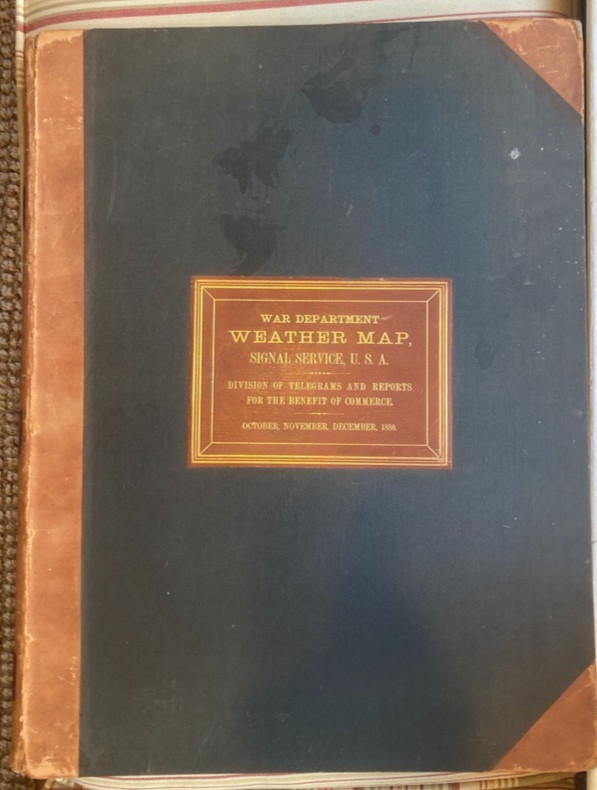
AN ORIGINAL WAR DEPARTMENT FOLIOThe atlas retains its substantial institutional binding, appropriately constructed for an enormous sequence of maps.
The heavy boards are covered in dark cloth with leather spine and corners.
The front cover carries a gilt-lettered label reading:
WAR DEPARTMENT
WEATHER MAP
SIGNAL SERVICE, U.S.A.
DIVISION OF TELEGRAMS AND REPORTS
FOR THE BENEFIT OF COMMERCE
OCTOBER, NOVEMBER, DECEMBER, 1880
The binding is monumental in scale.
At approximately 24 × 18 inches, the book is closer in presence to a large nineteenth-century geographical atlas than to an ordinary printed government report.
Its weight, approximately 29 pounds before packing, reflects the extraordinary quantity and dimensions of the original maps.
The substantial binding is itself a striking survival of the material culture of late nineteenth-century governmental scientific publication.
A PRIMARY SOURCE FOR HISTORIANS OF WEATHER AND CLIMATEBeyond its antiquarian and cartographic appeal, this atlas has potential research significance.
The original maps preserve observations made at particular moments during a historically important weather season.
Such nineteenth-century records provide material for historians investigating the development of atmospheric science, the early observing network, and the environmental conditions affecting American society.
The quarter covered by this volume is especially attractive for research into:
The winter of 1880–1881: The developing weather patterns of one of the most severe winters on the Great Plains.
American frontier life: Atmospheric conditions affecting the communities and agricultural settlements of the Upper Midwest and Dakota Territory.
Railroad and transportation history: The relationship between severe winter weather and nineteenth-century travel, freight, and communication networks.
The history of meteorological science: The development of organized national weather observation, telegraphic reporting, and daily weather-map production.
Historical climate research: Contemporary graphical meteorological records that can be examined alongside other surviving instrumental observations.
Scientific cartography: The evolution of techniques for visualizing pressure systems, temperature patterns, and atmospheric circulation.
Although historical copies and digitized examples of War Department weather maps survive in institutional collections, a substantial original quarterly volume offers an especially impressive physical record of the system in operation.
BIBLIOGRAPHICAL AND PHYSICAL DESCRIPTIONUNITED STATES WAR DEPARTMENT. U.S. ARMY SIGNAL SERVICE.
War Department Weather Map. Signal Service, U.S.A. Division of Telegrams and Reports for the Benefit of Commerce.
Fourth Quarter: October, November, December 1880.
Washington, D.C.: War Department, Signal Service, 1880.
Format: Imperial folio.
Dimensions: Approximately 24 × 18 inches.
Weight: Approximately 29 pounds, unpacked.
Contents: Large-format printed meteorological maps of the United States, recording observations at 7:35 A.M., 4:35 P.M., and 11:00 P.M., Washington time.
Map count: Approximately 270+ maps. A full quarter at three maps daily would comprise 276 maps; the precise number present has not been independently verified by a complete leaf-by-leaf count.
Period covered: October 1 through December 31, 1880.
Binding: Original heavy institutional half-leather binding with dark cloth-covered boards and gilt-lettered front label.
Historical significance: Produced during the first decade of organized national weather mapping by the U.S. Army Signal Service and covering the opening months of the exceptionally severe winter of 1880–1881.
CONDITIONVery Good overall for a large, heavily constructed nineteenth-century government atlas, with binding wear and well-preserved maps.
The maps are generally exceptionally attractive for their age, with relatively clean paper, strong color, clear printing, and well-preserved meteorological detail.
The station observations, atmospheric contours, place names, and other cartographic elements remain readily legible.
The original institutional binding shows age-related wear, particularly to the leather spine, corners, and board edges.
There is rubbing, abrasion, and localized surface wear to the leather and cloth. The front hinge shows wear, and the inner hinges have been reinforced to provide additional support for the exceptionally heavy text block.
The boards remain attached and the volume may be consulted with appropriate care and support.
Individual sheets may exhibit occasional toning, minor spotting, creases, or other age-related imperfections.
Because of the volume's considerable weight and dimensions, it should be handled on a sufficiently large, stable surface.
Please examine all photographs carefully for the binding, original label, map details, coloration, and condition.
IMPORTANT SHIPPING NOTE: This atlas weighs approximately 29 pounds before protective packing and measures approximately 24 × 18 inches. Shipping will require a substantial custom-sized package and careful reinforcement to protect the boards, corners, and internal maps. Shipping costs may be considerable.
A MONUMENTAL DOCUMENT OF EARLY AMERICAN METEOROLOGYAn extraordinary large-format survival from the pioneering years of the United States national weather service.
Containing approximately 270 or more original weather maps from the final quarter of 1880, this atlas provides a detailed contemporary record of the atmospheric conditions accompanying the beginning of the legendary Long Winter of 1880–1881.
A substantial nineteenth-century scientific atlas of unusual scale, historical interest, and visual appeal.
An especially compelling acquisition for collectors and institutions devoted to American scientific history, meteorology, nineteenth-century cartography, environmental history, the U.S. Army Signal Service, and the history of the American Great Plains.
Related Items:
1880s HD2a Abraham Lincoln US President Trade Card Spencer & Perkins SGC 4 VG-EX
$650.00
1880 US ARMY SIGNAL SERVICE WEATHER MAP ATLAS 270+ Maps WAR DEPARTMENT FOLIO
$1495.00

US Indian Wars Government Issued 1880's Tin Cup Mug Stamped M N G Michigan RARE
$179.99
