
1924 Large (52 x 17.5 in.) 'Map of the Pikes Peak Ocean to Ocean Highway...' For Sale
When you click on links to various merchants on this site and make a purchase, this can result in this site earning a commission. Affiliate programs and affiliations include, but are not limited to, the eBay Partner Network.

1924 Large (52 x 17.5 in.) 'Map of the Pikes Peak Ocean to Ocean Highway...':
$1600.00
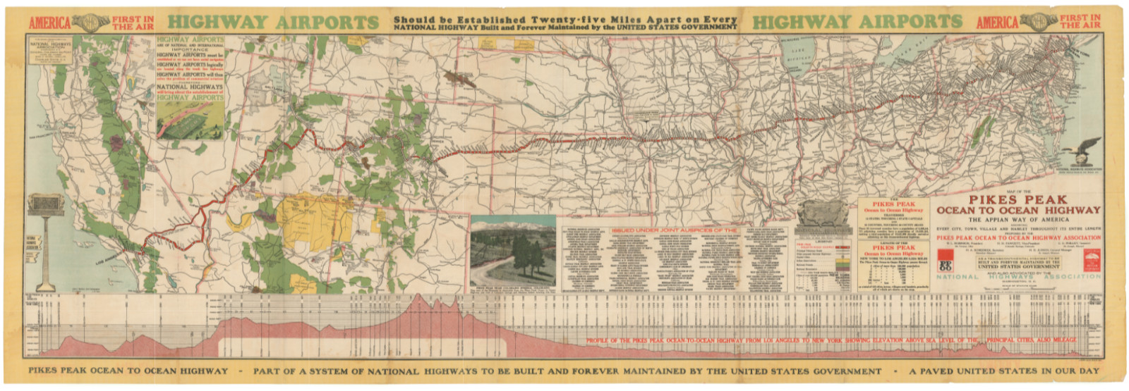
132 × 44.5 cm (52 x 17.5 in)Map of the Pikes Peak Ocean to Ocean Highway: the Appian way of America…This fantastic persuasive map displays two great infrastructure dreams of the 1920s: a national paved automobile road system and airway connectivity. Spread across a panoramic sheet more than three feet wide, it traces the Pikes Peak Ocean to Ocean Highway in red from New York to Los Angeles. The map promotes these 3,286 miles as “the shortest transcontinental highway in the United States” and “The Appian Way of America.”The Map in Detail
The central panel is a colored route map of the continental United States, with the PPOO Highway traced in a bold red line from the Atlantic seaboard to Southern California. The route threads through the industrial Midwest, across Kansas and Colorado (skirting Denver, avoiding city traffic delays by design), over the Rockies via Tennessee Pass at 10,400 feet, through Utah and Nevada, and down through the Mojave Desert into Los Angeles. Inset at center is a photographic view of Pikes Peak, Colorado, the landmark that lent the highway its name and its claim to scenic grandeur. The right panel carries the formal cartouche with title, organizational credits, legend, and route statistics.
An elevation profile spans the full width of the lower margin, showing the entire route from Los Angeles to New York, with principal cities labeled and mileage noted at intervals. It is a remarkable graphic in its own right, making visible the continent’s topography as the highway traveler would experience it, from the flat Atlantic coastal plain, through the rolling Midwest, up into the Rocky Mountain peaks, and down across the desert to sea level.
The upper-left panel carries the “Highway Airports” advocacy text, arguing for government-maintained airfields at regular intervals along every national highway, a network that would have given America a landing strip every twenty-five miles across the continent.Historical Context
The Pikes Peak Ocean to Ocean Highway was formally organized on March 18, 1914, in St. Joseph, Missouri, as a competitor to the Lincoln Highway, which had bypassed Colorado entirely when designated in September 1913. Colorado boosters quickly aligned behind an alternative route that ran through Colorado Springs and within sight of Pikes Peak, giving the highway its name and its motto: The Appian Way of America, after the great road of ancient Rome. By 1924, after years of routing disputes, the western terminus was fixed at Los Angeles via the Arrowhead Trail, making the PPOO the 3,286-mile route shown on this map.
The National Highways Association, which co-advocates the route here and whose chief cartographer, John C. Mulford, produced the map, was one of the era’s most prolific highway-promotion organizations, producing elaborate colored maps arguing for a comprehensive national highway network to be built and maintained by the federal government. Its maps are among the most visually striking documents of the good-roads movement.Publication History and Census
A. Hoen & Co., Baltimore, Maryland, printed the map. It was issued jointly by the Pikes Peak Ocean to Ocean Highway Association and the National Highways Association, with John C. Mulford as chief cartographer.
Institutional holdings recorded in eight libraries: University of California, Davis (Shields Library); Wisconsin Historical Society Library; Wisconsin Historical Society Archives; University of Illinois at Urbana-Champaign; University of Wisconsin–Milwaukee (UWM Libraries); University of Chicago Library; New York State Library; and Harvard University (Harvard Library). Scarce on the market. Related Items:

1924 Large Gold Plated Crucifix Pendant 3 3/4" X 1 1/2" Doederlein Co. Baltimore
$355.95
1924 Large (52 x 17.5 in.) 'Map of the Pikes Peak Ocean to Ocean Highway...'
$1600.00
Original July 28 1924 Ku Klux Klan-KKK Night Gathering Photograph-Large Assembly
$1495.00
